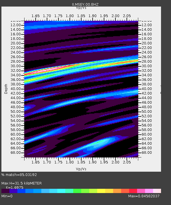
MSEY Mahe, Seychelles - Earthquake Result Viewer
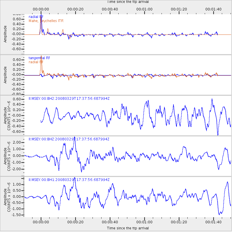
Earthquake location: Off W Coast Of Northern Sumatra
Earthquake latitude/longitude: 2.9/95.3
Earthquake time(UTC): 2008/03/29 (089) 17:30:50 GMT
Earthquake Depth: 20 km
Earthquake Magnitude: 5.8 MB, 6.5 MS, 6.3 MW, 6.3 MW
Earthquake Catalog/Contributor: WHDF/NEIC
Network: II Global Seismograph Network (GSN - IRIS/IDA)
Station: MSEY Mahe, Seychelles
Lat/Lon: 4.67 S/55.48 E
Elevation: 475 m
Distance: 40.5 deg
Az: 259.463 deg
Baz: 80.119 deg
Ray Param: 0.0743523
Estimated Moho Depth: 31.5 km
Estimated Crust Vp/Vs: 1.70
Assumed Crust Vp: 6.303 km/s
Estimated Crust Vs: 3.713 km/s
Estimated Crust Poisson's Ratio: 0.23
Radial Match: 85.03192 %
Radial Bump: 345
Transverse Match: 58.32987 %
Transverse Bump: 400
SOD ConfigId: 590571
Insert Time: 2013-09-26 21:26:25.467 +0000
GWidth: 2.5
Max Bumps: 400
Tol: 0.001

Signal To Noise

ChannelStoNSTALTA
II:MSEY:00:BHZ:20080329T17:37:56.687994Z2.80004842.97147E-71.0612209E-7
II:MSEY:00:BH1:20080329T17:37:56.687994Z2.86612322.33119E-78.1336E-8
II:MSEY:00:BH2:20080329T17:37:56.687994Z0.643169349.022047E-81.4027482E-7
Arrivals
Ps3.7 SECOND
PpPs13 SECOND
PsPs/PpSs16 SECOND