You are here: Home > Network List > IU - Global Seismograph Network (GSN - IRIS/USGS) Stations List
> Station RSSD Black Hills, South Dakota, USA > Earthquake Result Viewer
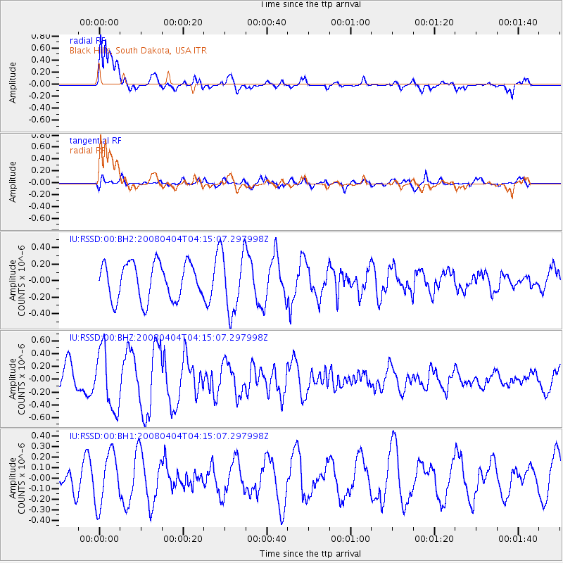
RSSD Black Hills, South Dakota, USA - Earthquake Result Viewer
*The percent match for this event was below the threshold and hence no stack was calculated.
| Earthquake location: |
Samoa Islands Region |
| Earthquake latitude/longitude: |
-15.3/-172.8 |
| Earthquake time(UTC): |
2008/04/04 (095) 04:03:01 GMT |
| Earthquake Depth: |
34 km |
| Earthquake Magnitude: |
5.5 MW |
| Earthquake Catalog/Contributor: |
NEIC PDE/NEIC PDE-M |
|
| Network: |
IU Global Seismograph Network (GSN - IRIS/USGS) |
| Station: |
RSSD Black Hills, South Dakota, USA |
| Lat/Lon: |
44.12 N/104.04 W |
| Elevation: |
2060 m |
|
| Distance: |
86.0 deg |
| Az: |
42.307 deg |
| Baz: |
244.418 deg |
| Ray Param: |
$rayparam |
*The percent match for this event was below the threshold and hence was not used in the summary stack. |
|
| Radial Match: |
74.304214 % |
| Radial Bump: |
400 |
| Transverse Match: |
71.94147 % |
| Transverse Bump: |
400 |
| SOD ConfigId: |
590571 |
| Insert Time: |
2013-09-26 21:34:43.432 +0000 |
| GWidth: |
2.5 |
| Max Bumps: |
400 |
| Tol: |
0.001 |
|
Signal To Noise
| Channel | StoN | STA | LTA |
| IU:RSSD:00:BHZ:20080404T04:15:07.297998Z | 2.1826618 | 4.7471346E-7 | 2.1749291E-7 |
| IU:RSSD:00:BH1:20080404T04:15:07.297998Z | 1.8248993 | 2.5277689E-7 | 1.3851552E-7 |
| IU:RSSD:00:BH2:20080404T04:15:07.297998Z | 1.6502054 | 3.625239E-7 | 2.196841E-7 |
| Arrivals |
| Ps | |
| PpPs | |
| PsPs/PpSs | |


