You are here: Home > Network List > II - Global Seismograph Network (GSN - IRIS/IDA) Stations List
> Station PALK Pallekele, Sri Lanka > Earthquake Result Viewer
PALK Pallekele, Sri Lanka - Earthquake Result Viewer
| Earthquake location: |
Macquarie Island Region |
| Earthquake latitude/longitude: |
-55.7/158.5 |
| Earthquake time(UTC): |
2008/04/12 (103) 00:30:12 GMT |
| Earthquake Depth: |
16 km |
| Earthquake Magnitude: |
6.8 MB, 7.1 MS, 7.1 MW, 7.1 MW |
| Earthquake Catalog/Contributor: |
WHDF/NEIC |
|
| Network: |
II Global Seismograph Network (GSN - IRIS/IDA) |
| Station: |
PALK Pallekele, Sri Lanka |
| Lat/Lon: |
7.27 N/80.70 E |
| Elevation: |
460 m |
|
| Distance: |
89.1 deg |
| Az: |
284.165 deg |
| Baz: |
146.372 deg |
| Ray Param: |
0.04208379 |
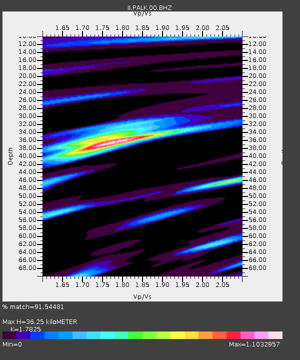
| Estimated Moho Depth: |
36.25 km |
| Estimated Crust Vp/Vs: |
1.78 |
| Assumed Crust Vp: |
6.545 km/s |
| Estimated Crust Vs: |
3.672 km/s |
| Estimated Crust Poisson's Ratio: |
0.27 |
|
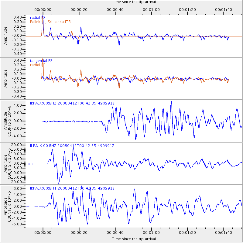
| Radial Match: |
91.54481 % |
| Radial Bump: |
312 |
| Transverse Match: |
90.701904 % |
| Transverse Bump: |
367 |
| SOD ConfigId: |
590571 |
| Insert Time: |
2013-09-26 22:03:19.864 +0000 |
| GWidth: |
2.5 |
| Max Bumps: |
400 |
| Tol: |
0.001 |
|
Signal To Noise
| Channel | StoN | STA | LTA |
| II:PALK:00:BHZ:20080412T00:42:35.490991Z | 31.66282 | 3.7887642E-6 | 1.1965972E-7 |
| II:PALK:00:BH1:20080412T00:42:35.490991Z | 11.5131645 | 1.0656873E-6 | 9.25625E-8 |
| II:PALK:00:BH2:20080412T00:42:35.490991Z | 9.907973 | 6.9185796E-7 | 6.98284E-8 |
| Arrivals |
| Ps | 4.4 SECOND |
| PpPs | 15 SECOND |
| PsPs/PpSs | 20 SECOND |


