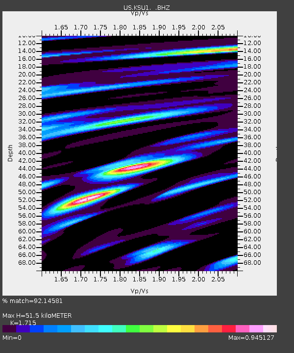
KSU1 Kansas State University--Konza Prairie, Kansas, USA - Earthquake Result Viewer
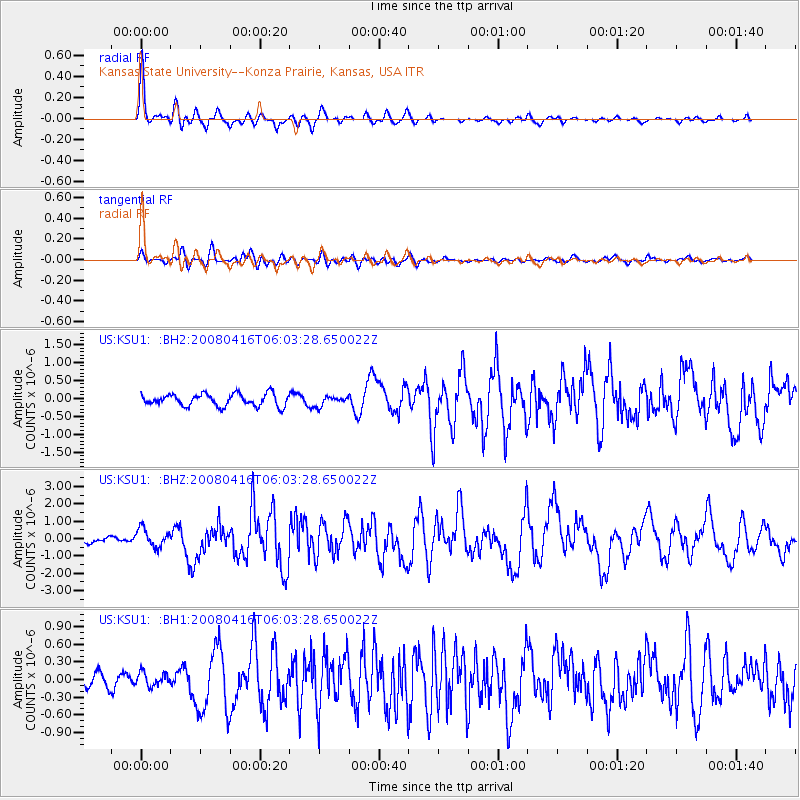
Earthquake location: Andreanof Islands, Aleutian Is.
Earthquake latitude/longitude: 51.9/-179.2
Earthquake time(UTC): 2008/04/16 (107) 05:54:19 GMT
Earthquake Depth: 13 km
Earthquake Magnitude: 6.1 MB, 6.5 MS, 6.6 MW, 6.6 MW
Earthquake Catalog/Contributor: WHDF/NEIC
Network: US United States National Seismic Network
Station: KSU1 Kansas State University--Konza Prairie, Kansas, USA
Lat/Lon: 39.10 N/96.61 W
Elevation: 347 m
Distance: 56.3 deg
Az: 68.093 deg
Baz: 312.341 deg
Ray Param: 0.064248756
Estimated Moho Depth: 51.5 km
Estimated Crust Vp/Vs: 1.72
Assumed Crust Vp: 6.483 km/s
Estimated Crust Vs: 3.78 km/s
Estimated Crust Poisson's Ratio: 0.24
Radial Match: 92.14581 %
Radial Bump: 339
Transverse Match: 78.26162 %
Transverse Bump: 400
SOD ConfigId: 590571
Insert Time: 2013-09-26 22:18:25.086 +0000
GWidth: 2.5
Max Bumps: 400
Tol: 0.001

Signal To Noise

ChannelStoNSTALTA
US:KSU1: :BHZ:20080416T06:03:28.650022Z3.27673985.233774E-71.5972505E-7
US:KSU1: :BH1:20080416T06:03:28.650022Z0.622695151.15708886E-71.8581947E-7
US:KSU1: :BH2:20080416T06:03:28.650022Z0.77069091.2997748E-71.686506E-7
Arrivals
Ps6.0 SECOND
PpPs20 SECOND
PsPs/PpSs26 SECOND