You are here: Home > Network List > IU - Global Seismograph Network (GSN - IRIS/USGS) Stations List
> Station RSSD Black Hills, South Dakota, USA > Earthquake Result Viewer
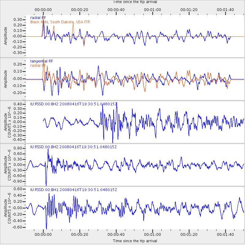
RSSD Black Hills, South Dakota, USA - Earthquake Result Viewer
*The percent match for this event was below the threshold and hence no stack was calculated.
| Earthquake location: |
Eastern Honshu, Japan |
| Earthquake latitude/longitude: |
39.0/140.0 |
| Earthquake time(UTC): |
2008/04/16 (107) 19:19:36 GMT |
| Earthquake Depth: |
166 km |
| Earthquake Magnitude: |
5.6 MB, 5.8 MW, 5.8 MW |
| Earthquake Catalog/Contributor: |
WHDF/NEIC |
|
| Network: |
IU Global Seismograph Network (GSN - IRIS/USGS) |
| Station: |
RSSD Black Hills, South Dakota, USA |
| Lat/Lon: |
44.12 N/104.04 W |
| Elevation: |
2060 m |
|
| Distance: |
79.1 deg |
| Az: |
41.262 deg |
| Baz: |
314.5 deg |
| Ray Param: |
$rayparam |
*The percent match for this event was below the threshold and hence was not used in the summary stack. |
|
| Radial Match: |
52.395603 % |
| Radial Bump: |
400 |
| Transverse Match: |
66.08414 % |
| Transverse Bump: |
400 |
| SOD ConfigId: |
590571 |
| Insert Time: |
2013-09-26 22:21:41.994 +0000 |
| GWidth: |
2.5 |
| Max Bumps: |
400 |
| Tol: |
0.001 |
|
Signal To Noise
| Channel | StoN | STA | LTA |
| IU:RSSD:00:BHZ:20080416T19:30:51.048015Z | 3.189142 | 4.0968473E-7 | 1.2846237E-7 |
| IU:RSSD:00:BH1:20080416T19:30:51.048015Z | 2.2726526 | 2.2643829E-7 | 9.9636125E-8 |
| IU:RSSD:00:BH2:20080416T19:30:51.048015Z | 2.3527956 | 1.505506E-7 | 6.398796E-8 |
| Arrivals |
| Ps | |
| PpPs | |
| PsPs/PpSs | |


