You are here: Home > Network List > KZ - Kazakhstan Network Stations List
> Station KUR21 Cross-array, Kurchatov, Kazakstan > Earthquake Result Viewer
KUR21 Cross-array, Kurchatov, Kazakstan - Earthquake Result Viewer
| Earthquake location: |
Taiwan Region |
| Earthquake latitude/longitude: |
22.9/121.6 |
| Earthquake time(UTC): |
2008/04/23 (114) 18:28:41 GMT |
| Earthquake Depth: |
10 km |
| Earthquake Magnitude: |
5.6 MB, 5.9 MS, 6.0 MW, 6.0 MW |
| Earthquake Catalog/Contributor: |
WHDF/NEIC |
|
| Network: |
KZ Kazakhstan Network |
| Station: |
KUR21 Cross-array, Kurchatov, Kazakstan |
| Lat/Lon: |
50.62 N/78.53 E |
| Elevation: |
200 m |
|
| Distance: |
43.4 deg |
| Az: |
320.672 deg |
| Baz: |
113.425 deg |
| Ray Param: |
0.07260215 |
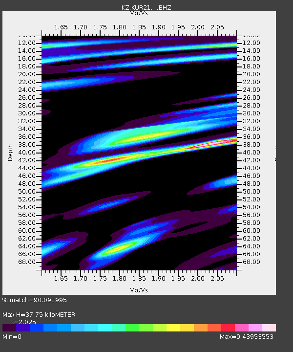
| Estimated Moho Depth: |
37.75 km |
| Estimated Crust Vp/Vs: |
2.03 |
| Assumed Crust Vp: |
6.552 km/s |
| Estimated Crust Vs: |
3.236 km/s |
| Estimated Crust Poisson's Ratio: |
0.34 |
|
| Radial Match: |
90.091995 % |
| Radial Bump: |
400 |
| Transverse Match: |
95.41353 % |
| Transverse Bump: |
341 |
| SOD ConfigId: |
590571 |
| Insert Time: |
2013-09-26 22:34:20.488 +0000 |
| GWidth: |
2.5 |
| Max Bumps: |
400 |
| Tol: |
0.001 |
|

Signal To Noise
| Channel | StoN | STA | LTA |
| KZ:KUR21: :BHZ:20080423T18:36:13.325007Z | 8.075288 | 3.7739738E-7 | 4.6734854E-8 |
| KZ:KUR21: :BH1:20080423T18:36:13.325007Z | 4.5231967 | 1.849772E-7 | 4.0895234E-8 |
| KZ:KUR21: :BH2:20080423T18:36:13.325007Z | 3.2709994 | 1.00635106E-7 | 3.0765857E-8 |
| Arrivals |
| Ps | 6.3 SECOND |
| PpPs | 16 SECOND |
| PsPs/PpSs | 23 SECOND |


