You are here: Home > Network List > TA - USArray Transportable Network (new EarthScope stations) Stations List
> Station G59A Clarenceville, QC, USA > Earthquake Result Viewer
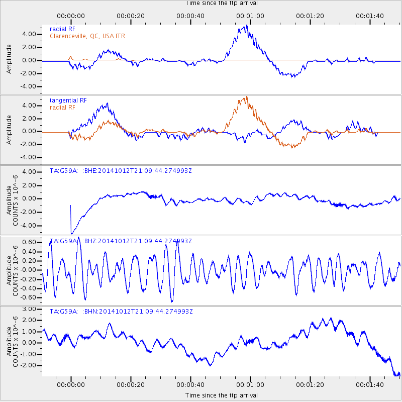
G59A Clarenceville, QC, USA - Earthquake Result Viewer
*The percent match for this event was below the threshold and hence no stack was calculated.
| Earthquake location: |
Central Mediterranean Sea |
| Earthquake latitude/longitude: |
35.6/21.6 |
| Earthquake time(UTC): |
2014/10/12 (285) 20:59:14 GMT |
| Earthquake Depth: |
35 km |
| Earthquake Magnitude: |
4.7 mb |
| Earthquake Catalog/Contributor: |
ISC/ISC |
|
| Network: |
TA USArray Transportable Network (new EarthScope stations) |
| Station: |
G59A Clarenceville, QC, USA |
| Lat/Lon: |
45.08 N/73.18 W |
| Elevation: |
36 m |
|
| Distance: |
68.8 deg |
| Az: |
310.789 deg |
| Baz: |
60.606 deg |
| Ray Param: |
$rayparam |
*The percent match for this event was below the threshold and hence was not used in the summary stack. |
|
| Radial Match: |
41.611717 % |
| Radial Bump: |
400 |
| Transverse Match: |
25.053879 % |
| Transverse Bump: |
400 |
| SOD ConfigId: |
3390531 |
| Insert Time: |
2019-04-14 12:41:45.835 +0000 |
| GWidth: |
2.5 |
| Max Bumps: |
400 |
| Tol: |
0.001 |
|
Signal To Noise
| Channel | StoN | STA | LTA |
| TA:G59A: :BHZ:20141012T21:09:44.274993Z | 1.6701244 | 4.2401422E-7 | 2.538818E-7 |
| TA:G59A: :BHN:20141012T21:09:44.274993Z | 0.78704983 | 2.0005261E-6 | 2.5418037E-6 |
| TA:G59A: :BHE:20141012T21:09:44.274993Z | 0.34668922 | 6.193602E-7 | 1.7864999E-6 |
| Arrivals |
| Ps | |
| PpPs | |
| PsPs/PpSs | |


