You are here: Home > Network List > TA - USArray Transportable Network (new EarthScope stations) Stations List
> Station J01E Myrtle Point, OR, USA > Earthquake Result Viewer
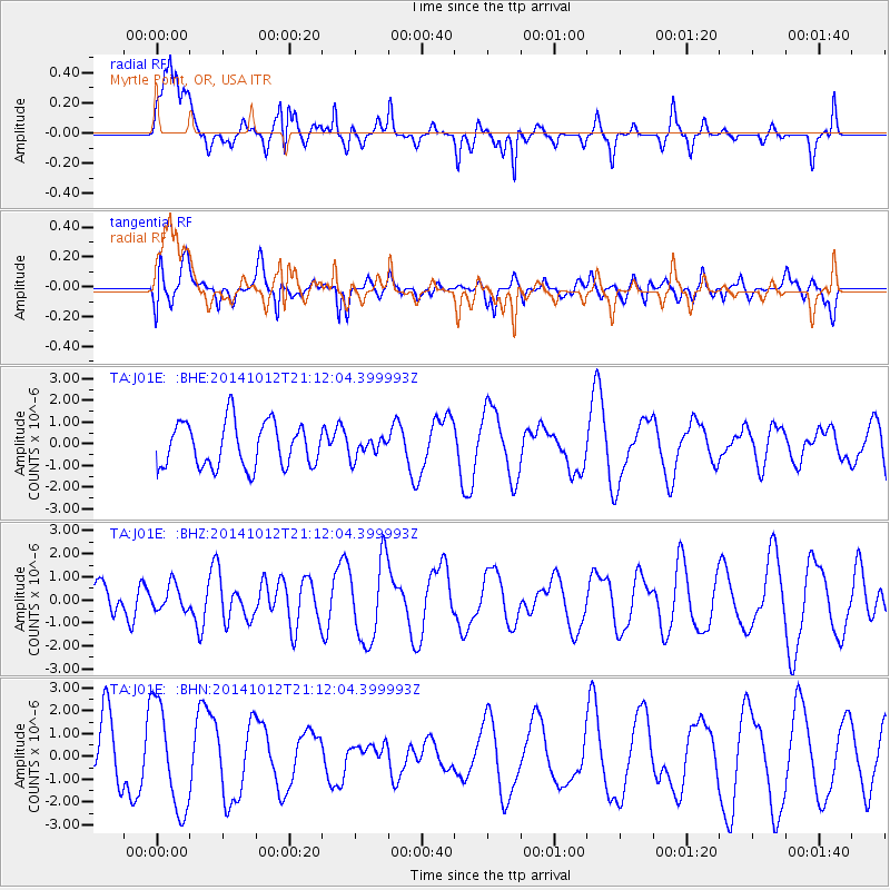
J01E Myrtle Point, OR, USA - Earthquake Result Viewer
*The percent match for this event was below the threshold and hence no stack was calculated.
| Earthquake location: |
Central Mediterranean Sea |
| Earthquake latitude/longitude: |
35.6/21.6 |
| Earthquake time(UTC): |
2014/10/12 (285) 20:59:14 GMT |
| Earthquake Depth: |
35 km |
| Earthquake Magnitude: |
4.7 mb |
| Earthquake Catalog/Contributor: |
ISC/ISC |
|
| Network: |
TA USArray Transportable Network (new EarthScope stations) |
| Station: |
J01E Myrtle Point, OR, USA |
| Lat/Lon: |
43.16 N/123.93 W |
| Elevation: |
128 m |
|
| Distance: |
95.6 deg |
| Az: |
335.38 deg |
| Baz: |
27.657 deg |
| Ray Param: |
$rayparam |
*The percent match for this event was below the threshold and hence was not used in the summary stack. |
|
| Radial Match: |
58.95526 % |
| Radial Bump: |
400 |
| Transverse Match: |
36.58078 % |
| Transverse Bump: |
400 |
| SOD ConfigId: |
3390531 |
| Insert Time: |
2019-04-14 12:41:51.944 +0000 |
| GWidth: |
2.5 |
| Max Bumps: |
400 |
| Tol: |
0.001 |
|
Signal To Noise
| Channel | StoN | STA | LTA |
| TA:J01E: :BHZ:20141012T21:12:04.399993Z | 0.6332213 | 5.452804E-7 | 8.6112135E-7 |
| TA:J01E: :BHN:20141012T21:12:04.399993Z | 1.4627899 | 2.2938368E-6 | 1.5681245E-6 |
| TA:J01E: :BHE:20141012T21:12:04.399993Z | 0.4322906 | 4.4267762E-7 | 1.0240278E-6 |
| Arrivals |
| Ps | |
| PpPs | |
| PsPs/PpSs | |


