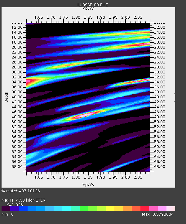
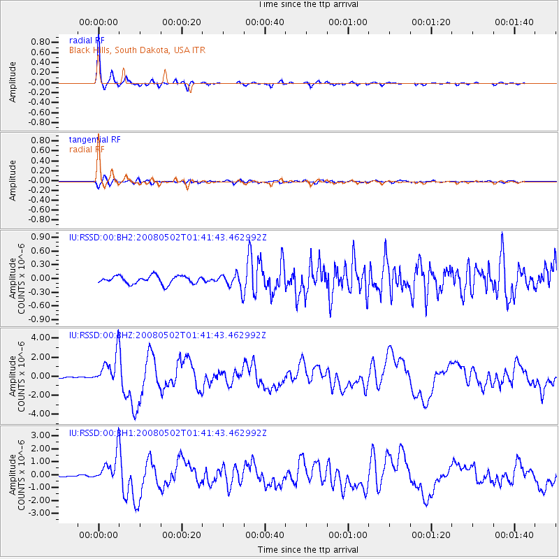
RSSD Black Hills, South Dakota, USA - Earthquake Result Viewer

Earthquake location: Andreanof Islands, Aleutian Is.
Earthquake latitude/longitude: 51.9/-177.5
Earthquake time(UTC): 2008/05/02 (123) 01:33:37 GMT
Earthquake Depth: 14 km
Earthquake Magnitude: 6.3 MB, 6.8 MS, 6.6 MW, 6.6 MW
Earthquake Catalog/Contributor: WHDF/NEIC
Network: IU Global Seismograph Network (GSN - IRIS/USGS)
Station: RSSD Black Hills, South Dakota, USA
Lat/Lon: 44.12 N/104.04 W
Elevation: 2060 m
Distance: 47.8 deg
Az: 68.67 deg
Baz: 306.677 deg
Ray Param: 0.069724195
Estimated Moho Depth: 47.0 km
Estimated Crust Vp/Vs: 1.84
Assumed Crust Vp: 6.242 km/s
Estimated Crust Vs: 3.402 km/s
Estimated Crust Poisson's Ratio: 0.29
Radial Match: 97.10126 %
Radial Bump: 209
Transverse Match: 77.37971 %
Transverse Bump: 400
SOD ConfigId: 590571
Insert Time: 2013-09-26 22:53:46.138 +0000
GWidth: 2.5
Max Bumps: 400
Tol: 0.001

Signal To Noise

ChannelStoNSTALTA
IU:RSSD:00:BHZ:20080502T01:41:43.462992Z19.9534971.7166137E-68.603072E-8
IU:RSSD:00:BH1:20080502T01:41:43.462992Z18.2275241.1716029E-66.4276584E-8
IU:RSSD:00:BH2:20080502T01:41:43.462992Z2.0511381.7637568E-78.5989186E-8
Arrivals
Ps6.6 SECOND
PpPs20 SECOND
PsPs/PpSs27 SECOND