You are here: Home > Network List > CI - Caltech Regional Seismic Network Stations List
> Station TIN Tinemaha, California, USA > Earthquake Result Viewer
TIN Tinemaha, California, USA - Earthquake Result Viewer
| Earthquake location: |
Kodiak Island Region, Alaska |
| Earthquake latitude/longitude: |
57.1/-153.2 |
| Earthquake time(UTC): |
2001/01/10 (010) 16:02:44 GMT |
| Earthquake Depth: |
33 km |
| Earthquake Magnitude: |
6.2 MB, 6.8 MS, 7.1 MW, 6.8 ML |
| Earthquake Catalog/Contributor: |
WHDF/NEIC |
|
| Network: |
CI Caltech Regional Seismic Network |
| Station: |
TIN Tinemaha, California, USA |
| Lat/Lon: |
37.05 N/118.23 W |
| Elevation: |
1164 m |
|
| Distance: |
30.6 deg |
| Az: |
115.776 deg |
| Baz: |
322.072 deg |
| Ray Param: |
0.07925362 |
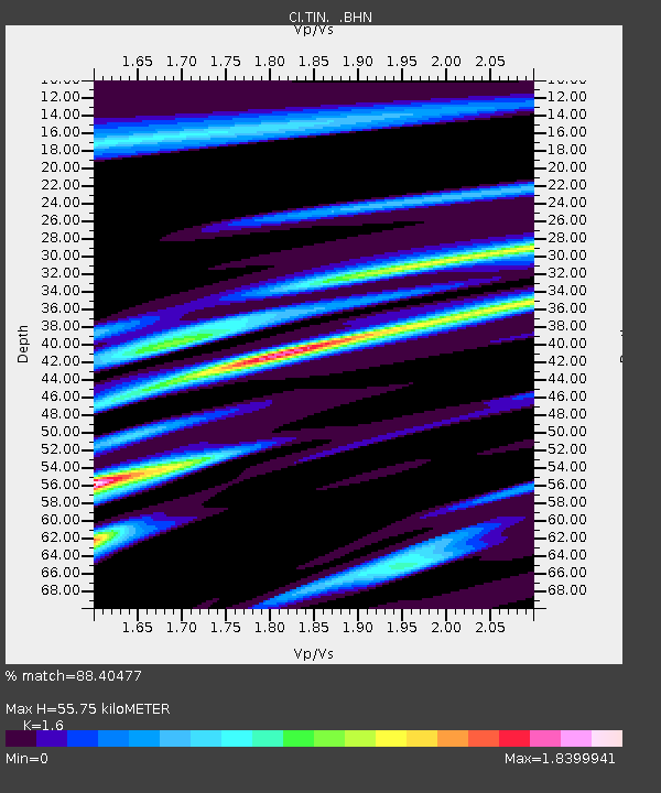
| Estimated Moho Depth: |
55.75 km |
| Estimated Crust Vp/Vs: |
1.60 |
| Assumed Crust Vp: |
6.291 km/s |
| Estimated Crust Vs: |
3.932 km/s |
| Estimated Crust Poisson's Ratio: |
0.18 |
|
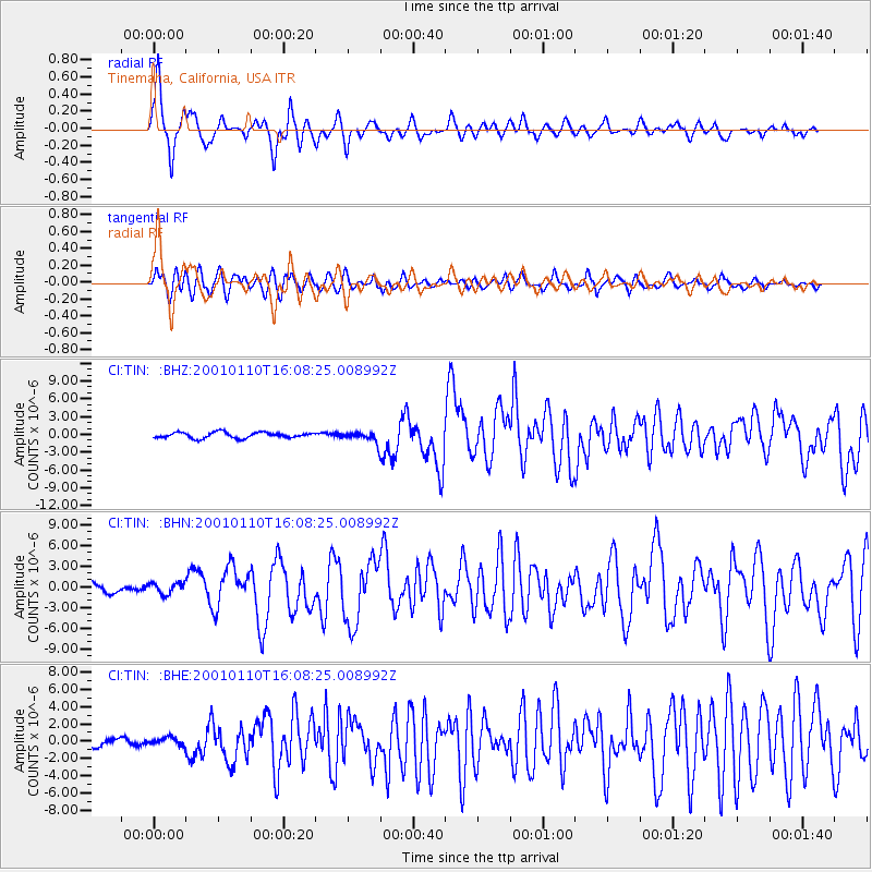
| Radial Match: |
88.40477 % |
| Radial Bump: |
348 |
| Transverse Match: |
83.9185 % |
| Transverse Bump: |
400 |
| SOD ConfigId: |
3744 |
| Insert Time: |
2010-02-25 20:46:21.872 +0000 |
| GWidth: |
2.5 |
| Max Bumps: |
400 |
| Tol: |
0.001 |
|
Signal To Noise
| Channel | StoN | STA | LTA |
| CI:TIN: :BHN:20010110T16:08:25.008992Z | 0.70766145 | 8.392454E-7 | 1.185942E-6 |
| CI:TIN: :BHE:20010110T16:08:25.008992Z | 0.8555278 | 4.535324E-7 | 5.3012E-7 |
| CI:TIN: :BHZ:20010110T16:08:25.008992Z | 1.821919 | 8.8626246E-7 | 4.864445E-7 |
| Arrivals |
| Ps | 5.8 SECOND |
| PpPs | 21 SECOND |
| PsPs/PpSs | 27 SECOND |


