You are here: Home > Network List > IU - Global Seismograph Network (GSN - IRIS/USGS) Stations List
> Station RSSD Black Hills, South Dakota, USA > Earthquake Result Viewer
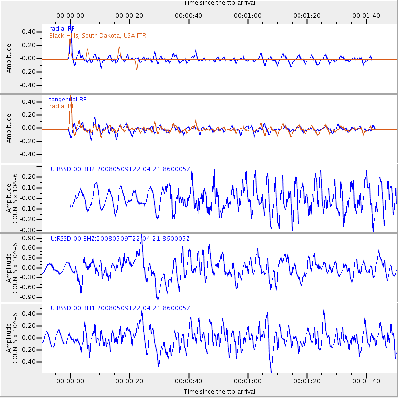
RSSD Black Hills, South Dakota, USA - Earthquake Result Viewer
*The percent match for this event was below the threshold and hence no stack was calculated.
| Earthquake location: |
South Of Mariana Islands |
| Earthquake latitude/longitude: |
12.5/143.2 |
| Earthquake time(UTC): |
2008/05/09 (130) 21:51:29 GMT |
| Earthquake Depth: |
76 km |
| Earthquake Magnitude: |
6.1 MB, 6.7 MW, 6.7 MW |
| Earthquake Catalog/Contributor: |
WHDF/NEIC |
|
| Network: |
IU Global Seismograph Network (GSN - IRIS/USGS) |
| Station: |
RSSD Black Hills, South Dakota, USA |
| Lat/Lon: |
44.12 N/104.04 W |
| Elevation: |
2060 m |
|
| Distance: |
97.1 deg |
| Az: |
41.997 deg |
| Baz: |
294.874 deg |
| Ray Param: |
$rayparam |
*The percent match for this event was below the threshold and hence was not used in the summary stack. |
|
| Radial Match: |
76.591354 % |
| Radial Bump: |
376 |
| Transverse Match: |
68.79839 % |
| Transverse Bump: |
400 |
| SOD ConfigId: |
590571 |
| Insert Time: |
2013-09-26 23:05:49.815 +0000 |
| GWidth: |
2.5 |
| Max Bumps: |
400 |
| Tol: |
0.001 |
|
Signal To Noise
| Channel | StoN | STA | LTA |
| IU:RSSD:00:BHZ:20080509T22:04:21.860005Z | 3.0110562 | 3.025665E-7 | 1.0048517E-7 |
| IU:RSSD:00:BH1:20080509T22:04:21.860005Z | 1.2022023 | 9.4102994E-8 | 7.82755E-8 |
| IU:RSSD:00:BH2:20080509T22:04:21.860005Z | 1.6286032 | 1.15591966E-7 | 7.0976135E-8 |
| Arrivals |
| Ps | |
| PpPs | |
| PsPs/PpSs | |


