You are here: Home > Network List > IU - Global Seismograph Network (GSN - IRIS/USGS) Stations List
> Station RSSD Black Hills, South Dakota, USA > Earthquake Result Viewer
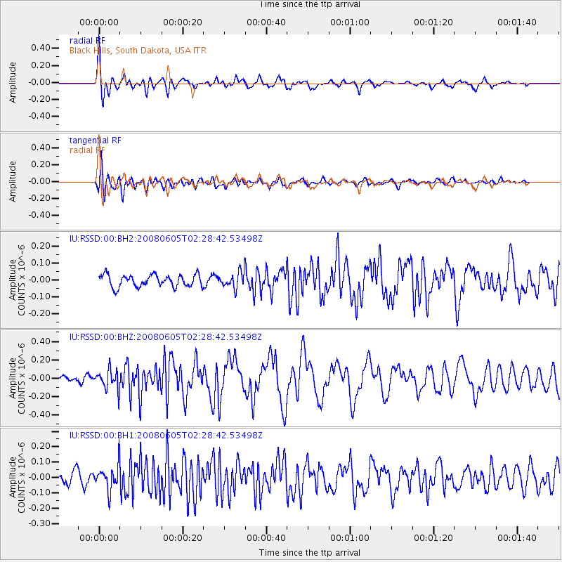
RSSD Black Hills, South Dakota, USA - Earthquake Result Viewer
*The percent match for this event was below the threshold and hence no stack was calculated.
| Earthquake location: |
West Chile Rise |
| Earthquake latitude/longitude: |
-38.8/-91.6 |
| Earthquake time(UTC): |
2008/06/05 (157) 02:16:46 GMT |
| Earthquake Depth: |
10 km |
| Earthquake Magnitude: |
5.6 MS, 5.4 MB, 6.0 MW, 6.0 MW |
| Earthquake Catalog/Contributor: |
WHDF/NEIC |
|
| Network: |
IU Global Seismograph Network (GSN - IRIS/USGS) |
| Station: |
RSSD Black Hills, South Dakota, USA |
| Lat/Lon: |
44.12 N/104.04 W |
| Elevation: |
2060 m |
|
| Distance: |
83.3 deg |
| Az: |
351.033 deg |
| Baz: |
170.27 deg |
| Ray Param: |
$rayparam |
*The percent match for this event was below the threshold and hence was not used in the summary stack. |
|
| Radial Match: |
83.769775 % |
| Radial Bump: |
379 |
| Transverse Match: |
72.72666 % |
| Transverse Bump: |
400 |
| SOD ConfigId: |
590571 |
| Insert Time: |
2013-09-27 00:16:15.574 +0000 |
| GWidth: |
2.5 |
| Max Bumps: |
400 |
| Tol: |
0.001 |
|
Signal To Noise
| Channel | StoN | STA | LTA |
| IU:RSSD:00:BHZ:20080605T02:28:42.53498Z | 2.3072057 | 1.0881693E-7 | 4.7163947E-8 |
| IU:RSSD:00:BH1:20080605T02:28:42.53498Z | 2.5543022 | 8.316611E-8 | 3.2559228E-8 |
| IU:RSSD:00:BH2:20080605T02:28:42.53498Z | 1.3686073 | 4.8917762E-8 | 3.574273E-8 |
| Arrivals |
| Ps | |
| PpPs | |
| PsPs/PpSs | |


