You are here: Home > Network List > KZ - Kazakhstan Network Stations List
> Station KUR21 Cross-array, Kurchatov, Kazakstan > Earthquake Result Viewer
KUR21 Cross-array, Kurchatov, Kazakstan - Earthquake Result Viewer
| Earthquake location: |
Northern Algeria |
| Earthquake latitude/longitude: |
35.9/-0.7 |
| Earthquake time(UTC): |
2008/06/06 (158) 20:02:56 GMT |
| Earthquake Depth: |
4.0 km |
| Earthquake Magnitude: |
5.5 MB, 5.3 MS, 5.5 MW, 5.5 MW |
| Earthquake Catalog/Contributor: |
WHDF/NEIC |
|
| Network: |
KZ Kazakhstan Network |
| Station: |
KUR21 Cross-array, Kurchatov, Kazakstan |
| Lat/Lon: |
50.62 N/78.53 E |
| Elevation: |
200 m |
|
| Distance: |
56.8 deg |
| Az: |
48.359 deg |
| Baz: |
287.682 deg |
| Ray Param: |
0.0638879 |
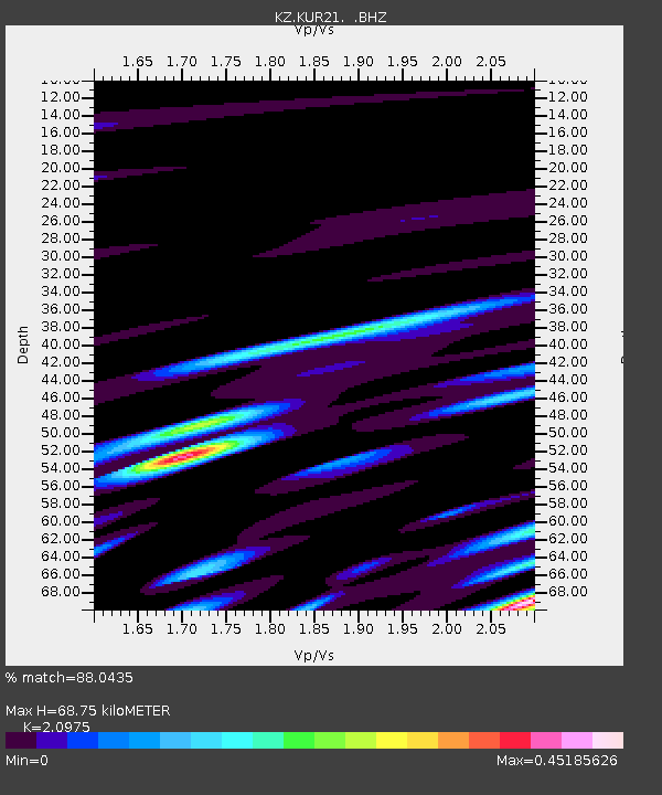
| Estimated Moho Depth: |
68.75 km |
| Estimated Crust Vp/Vs: |
2.10 |
| Assumed Crust Vp: |
6.552 km/s |
| Estimated Crust Vs: |
3.124 km/s |
| Estimated Crust Poisson's Ratio: |
0.35 |
|
| Radial Match: |
88.0435 % |
| Radial Bump: |
397 |
| Transverse Match: |
90.813934 % |
| Transverse Bump: |
322 |
| SOD ConfigId: |
590571 |
| Insert Time: |
2013-09-27 00:21:34.786 +0000 |
| GWidth: |
2.5 |
| Max Bumps: |
400 |
| Tol: |
0.001 |
|

Signal To Noise
| Channel | StoN | STA | LTA |
| KZ:KUR21: :BHZ:20080606T20:12:11.449998Z | 17.821682 | 9.79193E-7 | 5.4943918E-8 |
| KZ:KUR21: :BH1:20080606T20:12:11.449998Z | 24.248495 | 4.9016705E-7 | 2.021433E-8 |
| KZ:KUR21: :BH2:20080606T20:12:11.449998Z | 7.7996693 | 1.7734922E-7 | 2.2738044E-8 |
| Arrivals |
| Ps | 12 SECOND |
| PpPs | 31 SECOND |
| PsPs/PpSs | 43 SECOND |


