You are here: Home > Network List > IU - Global Seismograph Network (GSN - IRIS/USGS) Stations List
> Station RSSD Black Hills, South Dakota, USA > Earthquake Result Viewer
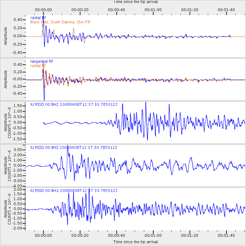
RSSD Black Hills, South Dakota, USA - Earthquake Result Viewer
*The percent match for this event was below the threshold and hence no stack was calculated.
| Earthquake location: |
Southern Greece |
| Earthquake latitude/longitude: |
38.0/21.5 |
| Earthquake time(UTC): |
2008/06/08 (160) 12:25:29 GMT |
| Earthquake Depth: |
16 km |
| Earthquake Magnitude: |
6.2 MB, 6.3 MS, 6.3 MW, 6.3 MW |
| Earthquake Catalog/Contributor: |
WHDF/NEIC |
|
| Network: |
IU Global Seismograph Network (GSN - IRIS/USGS) |
| Station: |
RSSD Black Hills, South Dakota, USA |
| Lat/Lon: |
44.12 N/104.04 W |
| Elevation: |
2060 m |
|
| Distance: |
84.6 deg |
| Az: |
323.95 deg |
| Baz: |
40.229 deg |
| Ray Param: |
$rayparam |
*The percent match for this event was below the threshold and hence was not used in the summary stack. |
|
| Radial Match: |
94.24668 % |
| Radial Bump: |
400 |
| Transverse Match: |
92.205444 % |
| Transverse Bump: |
400 |
| SOD ConfigId: |
590571 |
| Insert Time: |
2013-09-27 00:22:58.510 +0000 |
| GWidth: |
2.5 |
| Max Bumps: |
400 |
| Tol: |
0.001 |
|
Signal To Noise
| Channel | StoN | STA | LTA |
| IU:RSSD:00:BHZ:20080608T12:37:30.785012Z | 1.8892591 | 1.5975485E-7 | 8.4559524E-8 |
| IU:RSSD:00:BH1:20080608T12:37:30.785012Z | 1.047368 | 5.09786E-8 | 4.867305E-8 |
| IU:RSSD:00:BH2:20080608T12:37:30.785012Z | 1.02106 | 6.2215385E-8 | 6.093216E-8 |
| Arrivals |
| Ps | |
| PpPs | |
| PsPs/PpSs | |


