You are here: Home > Network List > II - Global Seismograph Network (GSN - IRIS/IDA) Stations List
> Station PALK Pallekele, Sri Lanka > Earthquake Result Viewer
PALK Pallekele, Sri Lanka - Earthquake Result Viewer
| Earthquake location: |
Eastern Honshu, Japan |
| Earthquake latitude/longitude: |
39.0/140.9 |
| Earthquake time(UTC): |
2008/06/13 (165) 23:43:45 GMT |
| Earthquake Depth: |
7.8 km |
| Earthquake Magnitude: |
6.9 MW, 6.5 MB, 6.8 MW, 7.0 MS |
| Earthquake Catalog/Contributor: |
NEIC PDE/NEIC PDE-M |
|
| Network: |
II Global Seismograph Network (GSN - IRIS/IDA) |
| Station: |
PALK Pallekele, Sri Lanka |
| Lat/Lon: |
7.27 N/80.70 E |
| Elevation: |
460 m |
|
| Distance: |
62.4 deg |
| Az: |
256.197 deg |
| Baz: |
49.68 deg |
| Ray Param: |
0.060249195 |
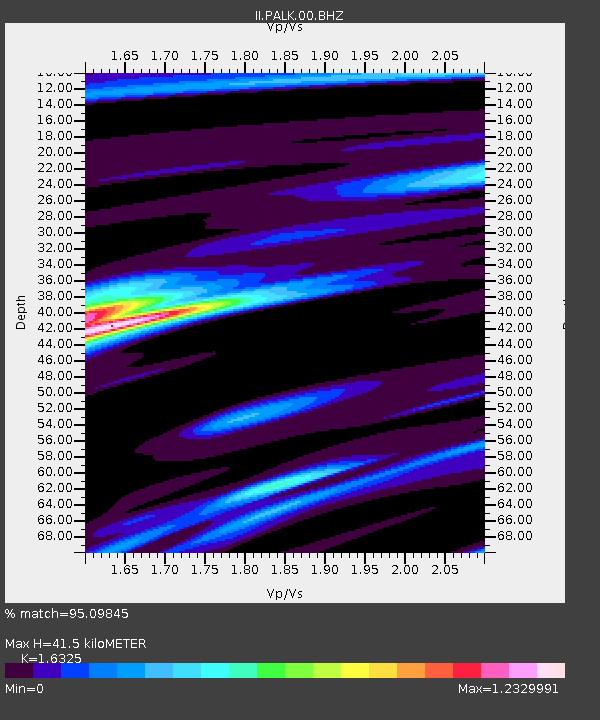
| Estimated Moho Depth: |
41.5 km |
| Estimated Crust Vp/Vs: |
1.63 |
| Assumed Crust Vp: |
6.545 km/s |
| Estimated Crust Vs: |
4.009 km/s |
| Estimated Crust Poisson's Ratio: |
0.20 |
|
| Radial Match: |
95.09845 % |
| Radial Bump: |
391 |
| Transverse Match: |
84.82856 % |
| Transverse Bump: |
400 |
| SOD ConfigId: |
590571 |
| Insert Time: |
2013-09-27 00:35:26.226 +0000 |
| GWidth: |
2.5 |
| Max Bumps: |
400 |
| Tol: |
0.001 |
|
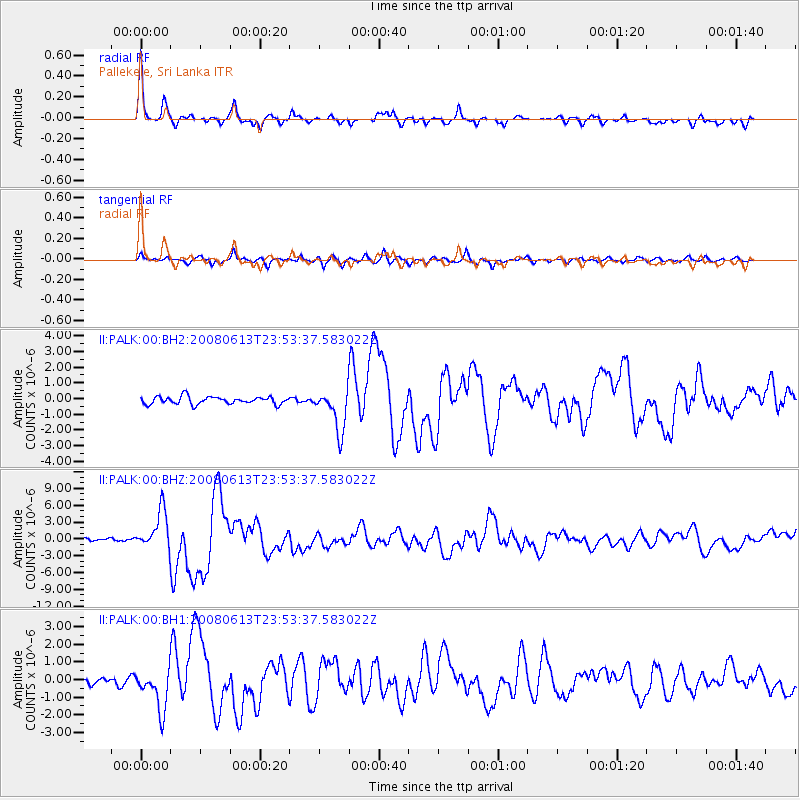
Signal To Noise
| Channel | StoN | STA | LTA |
| II:PALK:00:BHZ:20080613T23:53:37.583022Z | 15.523935 | 3.4719685E-6 | 2.236526E-7 |
| II:PALK:00:BH1:20080613T23:53:37.583022Z | 5.34751 | 1.1764444E-6 | 2.1999854E-7 |
| II:PALK:00:BH2:20080613T23:53:37.583022Z | 5.526519 | 1.321807E-6 | 2.3917534E-7 |
| Arrivals |
| Ps | 4.2 SECOND |
| PpPs | 16 SECOND |
| PsPs/PpSs | 20 SECOND |


