You are here: Home > Network List > IU - Global Seismograph Network (GSN - IRIS/USGS) Stations List
> Station RSSD Black Hills, South Dakota, USA > Earthquake Result Viewer
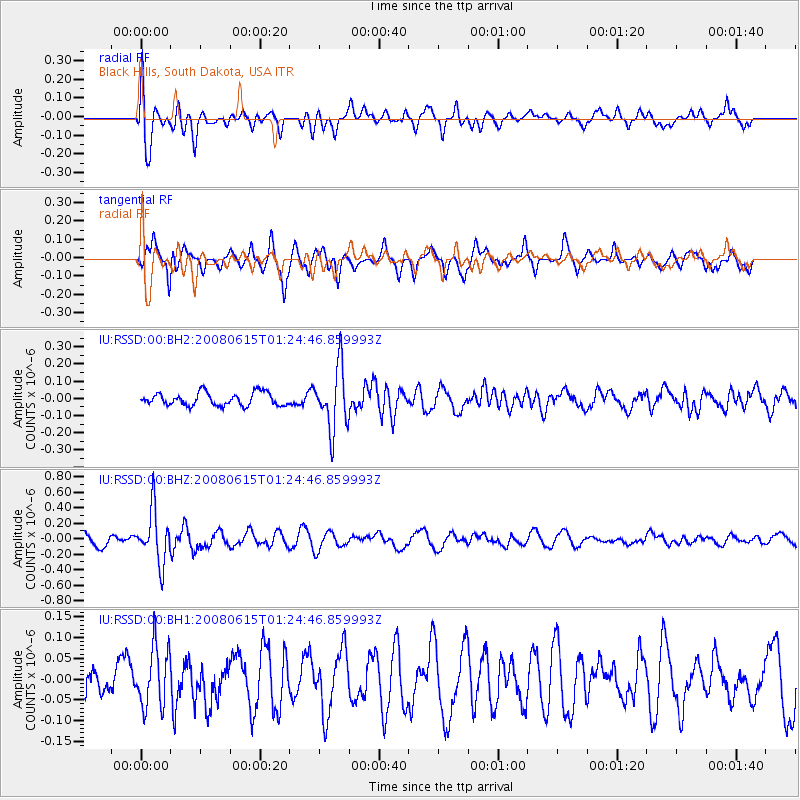
RSSD Black Hills, South Dakota, USA - Earthquake Result Viewer
*The percent match for this event was below the threshold and hence no stack was calculated.
| Earthquake location: |
Fiji Islands Region |
| Earthquake latitude/longitude: |
-17.7/-179.7 |
| Earthquake time(UTC): |
2008/06/15 (167) 01:13:11 GMT |
| Earthquake Depth: |
611 km |
| Earthquake Magnitude: |
5.5 MB, 5.9 MW, 5.9 MW |
| Earthquake Catalog/Contributor: |
WHDF/NEIC |
|
| Network: |
IU Global Seismograph Network (GSN - IRIS/USGS) |
| Station: |
RSSD Black Hills, South Dakota, USA |
| Lat/Lon: |
44.12 N/104.04 W |
| Elevation: |
2060 m |
|
| Distance: |
92.3 deg |
| Az: |
44.303 deg |
| Baz: |
247.56 deg |
| Ray Param: |
$rayparam |
*The percent match for this event was below the threshold and hence was not used in the summary stack. |
|
| Radial Match: |
64.8478 % |
| Radial Bump: |
400 |
| Transverse Match: |
61.23234 % |
| Transverse Bump: |
342 |
| SOD ConfigId: |
590571 |
| Insert Time: |
2013-09-27 00:37:51.654 +0000 |
| GWidth: |
2.5 |
| Max Bumps: |
400 |
| Tol: |
0.001 |
|
Signal To Noise
| Channel | StoN | STA | LTA |
| IU:RSSD:00:BHZ:20080615T01:24:46.859993Z | 4.7246084 | 3.371165E-7 | 7.135332E-8 |
| IU:RSSD:00:BH1:20080615T01:24:46.859993Z | 1.2763189 | 7.2561704E-8 | 5.6852333E-8 |
| IU:RSSD:00:BH2:20080615T01:24:46.859993Z | 4.8311114 | 1.7952198E-7 | 3.7159563E-8 |
| Arrivals |
| Ps | |
| PpPs | |
| PsPs/PpSs | |


