You are here: Home > Network List > US - United States National Seismic Network Stations List
> Station ECSD EROS Data Center, Sioux Falls, South Dakota, USA > Earthquake Result Viewer
ECSD EROS Data Center, Sioux Falls, South Dakota, USA - Earthquake Result Viewer
| Earthquake location: |
Sea Of Okhotsk |
| Earthquake latitude/longitude: |
53.9/152.9 |
| Earthquake time(UTC): |
2008/07/05 (187) 02:12:04 GMT |
| Earthquake Depth: |
633 km |
| Earthquake Magnitude: |
6.8 MB, 7.7 MW, 7.7 MW |
| Earthquake Catalog/Contributor: |
WHDF/NEIC |
|
| Network: |
US United States National Seismic Network |
| Station: |
ECSD EROS Data Center, Sioux Falls, South Dakota, USA |
| Lat/Lon: |
43.73 N/96.60 W |
| Elevation: |
469 m |
|
| Distance: |
66.1 deg |
| Az: |
47.943 deg |
| Baz: |
322.672 deg |
| Ray Param: |
0.055449508 |
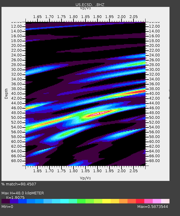
| Estimated Moho Depth: |
48.0 km |
| Estimated Crust Vp/Vs: |
1.91 |
| Assumed Crust Vp: |
6.498 km/s |
| Estimated Crust Vs: |
3.406 km/s |
| Estimated Crust Poisson's Ratio: |
0.31 |
|
| Radial Match: |
98.4587 % |
| Radial Bump: |
400 |
| Transverse Match: |
95.73082 % |
| Transverse Bump: |
400 |
| SOD ConfigId: |
590571 |
| Insert Time: |
2013-09-27 01:11:33.163 +0000 |
| GWidth: |
2.5 |
| Max Bumps: |
400 |
| Tol: |
0.001 |
|

Signal To Noise
| Channel | StoN | STA | LTA |
| US:ECSD: :BHZ:20080705T02:21:20.099019Z | 90.57466 | 2.0142355E-5 | 2.22384E-7 |
| US:ECSD: :BH1:20080705T02:21:20.099019Z | 47.27484 | 4.0517207E-6 | 8.5705636E-8 |
| US:ECSD: :BH2:20080705T02:21:20.099019Z | 50.84278 | 8.202179E-6 | 1.6132435E-7 |
| Arrivals |
| Ps | 6.9 SECOND |
| PpPs | 21 SECOND |
| PsPs/PpSs | 28 SECOND |


