You are here: Home > Network List > IU - Global Seismograph Network (GSN - IRIS/USGS) Stations List
> Station RSSD Black Hills, South Dakota, USA > Earthquake Result Viewer
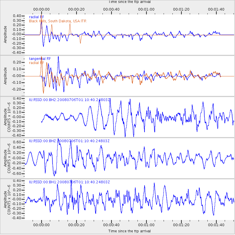
RSSD Black Hills, South Dakota, USA - Earthquake Result Viewer
*The percent match for this event was below the threshold and hence no stack was calculated.
| Earthquake location: |
Kuril Islands |
| Earthquake latitude/longitude: |
45.4/151.0 |
| Earthquake time(UTC): |
2008/07/06 (188) 01:00:08 GMT |
| Earthquake Depth: |
22 km |
| Earthquake Magnitude: |
5.7 MW, 5.5 MS, 5.5 MB, 5.7 MW |
| Earthquake Catalog/Contributor: |
NEIC PDE/NEIC PDE-M |
|
| Network: |
IU Global Seismograph Network (GSN - IRIS/USGS) |
| Station: |
RSSD Black Hills, South Dakota, USA |
| Lat/Lon: |
44.12 N/104.04 W |
| Elevation: |
2060 m |
|
| Distance: |
68.8 deg |
| Az: |
48.272 deg |
| Baz: |
313.058 deg |
| Ray Param: |
$rayparam |
*The percent match for this event was below the threshold and hence was not used in the summary stack. |
|
| Radial Match: |
67.57702 % |
| Radial Bump: |
400 |
| Transverse Match: |
85.7974 % |
| Transverse Bump: |
375 |
| SOD ConfigId: |
590571 |
| Insert Time: |
2013-09-27 01:12:34.444 +0000 |
| GWidth: |
2.5 |
| Max Bumps: |
400 |
| Tol: |
0.001 |
|
Signal To Noise
| Channel | StoN | STA | LTA |
| IU:RSSD:00:BHZ:20080706T01:10:40.24803Z | 1.9819527 | 2.1499585E-7 | 1.0847678E-7 |
| IU:RSSD:00:BH1:20080706T01:10:40.24803Z | 1.1615362 | 9.255337E-8 | 7.968187E-8 |
| IU:RSSD:00:BH2:20080706T01:10:40.24803Z | 3.848262 | 2.0603704E-7 | 5.3540283E-8 |
| Arrivals |
| Ps | |
| PpPs | |
| PsPs/PpSs | |


