You are here: Home > Network List > IU - Global Seismograph Network (GSN - IRIS/USGS) Stations List
> Station RSSD Black Hills, South Dakota, USA > Earthquake Result Viewer
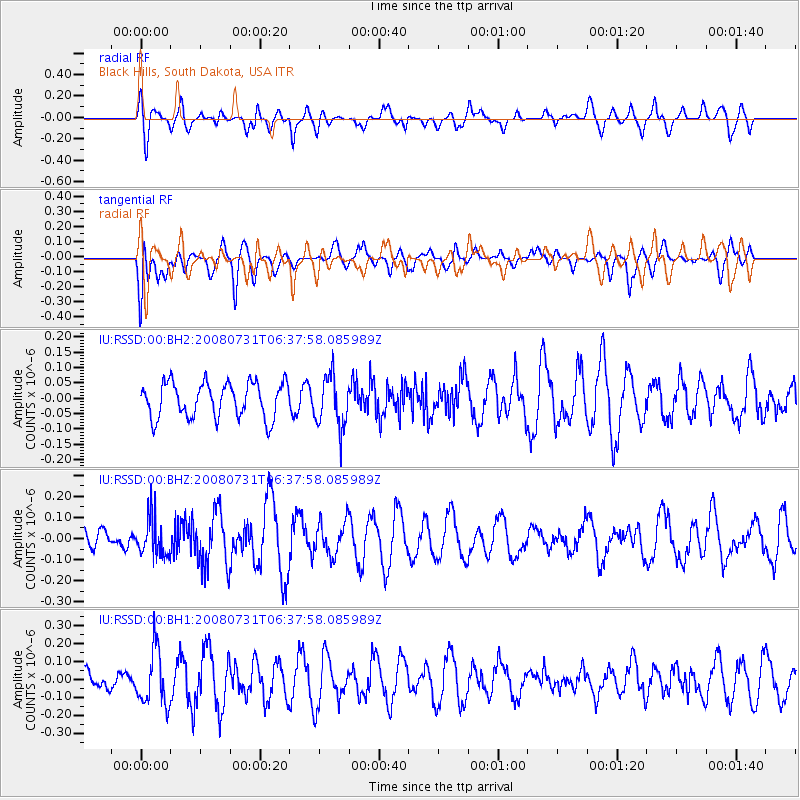
RSSD Black Hills, South Dakota, USA - Earthquake Result Viewer
*The percent match for this event was below the threshold and hence no stack was calculated.
| Earthquake location: |
Off Coast Of Central America |
| Earthquake latitude/longitude: |
12.7/-88.2 |
| Earthquake time(UTC): |
2008/07/31 (213) 06:31:49 GMT |
| Earthquake Depth: |
59 km |
| Earthquake Magnitude: |
5.6 MD |
| Earthquake Catalog/Contributor: |
NEIC PDE/NEIC PDE-M |
|
| Network: |
IU Global Seismograph Network (GSN - IRIS/USGS) |
| Station: |
RSSD Black Hills, South Dakota, USA |
| Lat/Lon: |
44.12 N/104.04 W |
| Elevation: |
2060 m |
|
| Distance: |
34.1 deg |
| Az: |
339.507 deg |
| Baz: |
151.681 deg |
| Ray Param: |
$rayparam |
*The percent match for this event was below the threshold and hence was not used in the summary stack. |
|
| Radial Match: |
54.107674 % |
| Radial Bump: |
400 |
| Transverse Match: |
56.594143 % |
| Transverse Bump: |
400 |
| SOD ConfigId: |
590571 |
| Insert Time: |
2013-09-27 02:14:52.943 +0000 |
| GWidth: |
2.5 |
| Max Bumps: |
400 |
| Tol: |
0.001 |
|
Signal To Noise
| Channel | StoN | STA | LTA |
| IU:RSSD:00:BHZ:20080731T06:37:58.085989Z | 2.1013753 | 9.2646815E-8 | 4.4088655E-8 |
| IU:RSSD:00:BH1:20080731T06:37:58.085989Z | 2.7075734 | 1.533955E-7 | 5.6654233E-8 |
| IU:RSSD:00:BH2:20080731T06:37:58.085989Z | 1.432475 | 8.191589E-8 | 5.7184867E-8 |
| Arrivals |
| Ps | |
| PpPs | |
| PsPs/PpSs | |


