You are here: Home > Network List > IU - Global Seismograph Network (GSN - IRIS/USGS) Stations List
> Station RSSD Black Hills, South Dakota, USA > Earthquake Result Viewer
RSSD Black Hills, South Dakota, USA - Earthquake Result Viewer
*The percent match for this event was below the threshold and hence no stack was calculated.
| Earthquake location: |
Near Coast Of Nicaragua |
| Earthquake latitude/longitude: |
12.6/-87.7 |
| Earthquake time(UTC): |
2008/08/07 (220) 23:41:27 GMT |
| Earthquake Depth: |
65 km |
| Earthquake Magnitude: |
5.6 MD |
| Earthquake Catalog/Contributor: |
NEIC PDE/NEIC PDE-M |
|
| Network: |
IU Global Seismograph Network (GSN - IRIS/USGS) |
| Station: |
RSSD Black Hills, South Dakota, USA |
| Lat/Lon: |
44.12 N/104.04 W |
| Elevation: |
2060 m |
|
| Distance: |
34.4 deg |
| Az: |
339.028 deg |
| Baz: |
150.975 deg |
| Ray Param: |
$rayparam |
*The percent match for this event was below the threshold and hence was not used in the summary stack. |
|
| Radial Match: |
72.649864 % |
| Radial Bump: |
400 |
| Transverse Match: |
61.474216 % |
| Transverse Bump: |
400 |
| SOD ConfigId: |
590571 |
| Insert Time: |
2013-09-27 02:31:38.761 +0000 |
| GWidth: |
2.5 |
| Max Bumps: |
400 |
| Tol: |
0.001 |
|
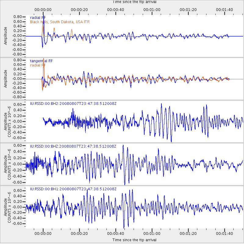
Signal To Noise
| Channel | StoN | STA | LTA |
| IU:RSSD:00:BHZ:20080807T23:47:38.512008Z | 1.3530846 | 1.5072247E-7 | 1.11391756E-7 |
| IU:RSSD:00:BH1:20080807T23:47:38.512008Z | 1.5964476 | 1.3147171E-7 | 8.2352656E-8 |
| IU:RSSD:00:BH2:20080807T23:47:38.512008Z | 1.0604621 | 1.18025085E-7 | 1.112959E-7 |
| Arrivals |
| Ps | |
| PpPs | |
| PsPs/PpSs | |


