You are here: Home > Network List > IU - Global Seismograph Network (GSN - IRIS/USGS) Stations List
> Station RSSD Black Hills, South Dakota, USA > Earthquake Result Viewer
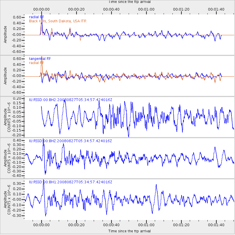
RSSD Black Hills, South Dakota, USA - Earthquake Result Viewer
*The percent match for this event was below the threshold and hence no stack was calculated.
| Earthquake location: |
Kuril Islands |
| Earthquake latitude/longitude: |
46.7/152.5 |
| Earthquake time(UTC): |
2008/08/27 (240) 05:24:41 GMT |
| Earthquake Depth: |
65 km |
| Earthquake Magnitude: |
5.5 MB, 5.4 MW, 5.3 MW |
| Earthquake Catalog/Contributor: |
WHDF/NEIC |
|
| Network: |
IU Global Seismograph Network (GSN - IRIS/USGS) |
| Station: |
RSSD Black Hills, South Dakota, USA |
| Lat/Lon: |
44.12 N/104.04 W |
| Elevation: |
2060 m |
|
| Distance: |
67.2 deg |
| Az: |
49.456 deg |
| Baz: |
313.46 deg |
| Ray Param: |
$rayparam |
*The percent match for this event was below the threshold and hence was not used in the summary stack. |
|
| Radial Match: |
60.1153 % |
| Radial Bump: |
379 |
| Transverse Match: |
41.98035 % |
| Transverse Bump: |
400 |
| SOD ConfigId: |
590571 |
| Insert Time: |
2013-09-27 03:16:38.576 +0000 |
| GWidth: |
2.5 |
| Max Bumps: |
400 |
| Tol: |
0.001 |
|
Signal To Noise
| Channel | StoN | STA | LTA |
| IU:RSSD:00:BHZ:20080827T05:34:57.424016Z | 3.602146 | 1.9268666E-7 | 5.3492183E-8 |
| IU:RSSD:00:BH1:20080827T05:34:57.424016Z | 1.7409959 | 1.6333564E-7 | 9.381736E-8 |
| IU:RSSD:00:BH2:20080827T05:34:57.424016Z | 0.90239 | 7.651729E-8 | 8.479403E-8 |
| Arrivals |
| Ps | |
| PpPs | |
| PsPs/PpSs | |


