You are here: Home > Network List > X812 - Deep Structure of Three Continental Sutures in Eastern North America Stations List
> Station QM16 Land Trust North, Maine, USA > Earthquake Result Viewer
QM16 Land Trust North, Maine, USA - Earthquake Result Viewer
| Earthquake location: |
Off Coast Of Central America |
| Earthquake latitude/longitude: |
12.6/-88.0 |
| Earthquake time(UTC): |
2014/10/14 (287) 03:51:35 GMT |
| Earthquake Depth: |
40 km |
| Earthquake Magnitude: |
7.3 MWW, 7.4 MI |
| Earthquake Catalog/Contributor: |
NEIC PDE/NEIC COMCAT |
|
| Network: |
X8 Deep Structure of Three Continental Sutures in Eastern North America |
| Station: |
QM16 Land Trust North, Maine, USA |
| Lat/Lon: |
45.21 N/67.95 W |
| Elevation: |
126 m |
|
| Distance: |
36.8 deg |
| Az: |
23.945 deg |
| Baz: |
214.093 deg |
| Ray Param: |
0.07642032 |
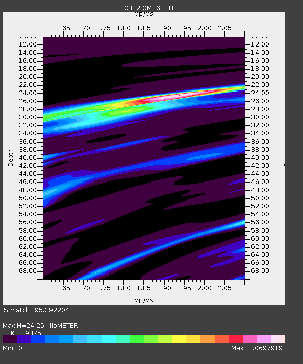
| Estimated Moho Depth: |
24.25 km |
| Estimated Crust Vp/Vs: |
1.94 |
| Assumed Crust Vp: |
6.419 km/s |
| Estimated Crust Vs: |
3.313 km/s |
| Estimated Crust Poisson's Ratio: |
0.32 |
|
| Radial Match: |
95.392204 % |
| Radial Bump: |
164 |
| Transverse Match: |
82.61635 % |
| Transverse Bump: |
400 |
| SOD ConfigId: |
3390531 |
| Insert Time: |
2019-04-14 13:20:27.983 +0000 |
| GWidth: |
2.5 |
| Max Bumps: |
400 |
| Tol: |
0.001 |
|

Signal To Noise
| Channel | StoN | STA | LTA |
| X8:QM16: :HHZ:20141014T03:58:08.050006Z | 32.839466 | 1.2098124E-5 | 3.6840197E-7 |
| X8:QM16: :HHN:20141014T03:58:08.050006Z | 21.94675 | 6.448754E-6 | 2.938364E-7 |
| X8:QM16: :HHE:20141014T03:58:08.050006Z | 32.61574 | 6.125929E-6 | 1.8782124E-7 |
| Arrivals |
| Ps | 3.8 SECOND |
| PpPs | 10 SECOND |
| PsPs/PpSs | 14 SECOND |


