You are here: Home > Network List > X812 - Deep Structure of Three Continental Sutures in Eastern North America Stations List
> Station QM20 Hay Lake, Maine, USA > Earthquake Result Viewer
QM20 Hay Lake, Maine, USA - Earthquake Result Viewer

| Earthquake location: |
Off Coast Of Central America |
| Earthquake latitude/longitude: |
12.6/-88.0 |
| Earthquake time(UTC): |
2014/10/14 (287) 03:51:35 GMT |
| Earthquake Depth: |
40 km |
| Earthquake Magnitude: |
7.3 MWW, 7.4 MI |
| Earthquake Catalog/Contributor: |
NEIC PDE/NEIC COMCAT |
|
| Network: |
X8 Deep Structure of Three Continental Sutures in Eastern North America |
| Station: |
QM20 Hay Lake, Maine, USA |
| Lat/Lon: |
46.13 N/68.72 W |
| Elevation: |
207 m |
|
| Distance: |
37.2 deg |
| Az: |
22.359 deg |
| Baz: |
212.278 deg |
| Ray Param: |
0.076162286 |
| Estimated Moho Depth: |
31.25 km |
| Estimated Crust Vp/Vs: |
1.86 |
| Assumed Crust Vp: |
6.419 km/s |
| Estimated Crust Vs: |
3.456 km/s |
| Estimated Crust Poisson's Ratio: |
0.30 |
|
| Radial Match: |
94.62628 % |
| Radial Bump: |
286 |
| Transverse Match: |
85.08395 % |
| Transverse Bump: |
367 |
| SOD ConfigId: |
3390531 |
| Insert Time: |
2019-04-14 13:20:30.142 +0000 |
| GWidth: |
2.5 |
| Max Bumps: |
400 |
| Tol: |
0.001 |
|
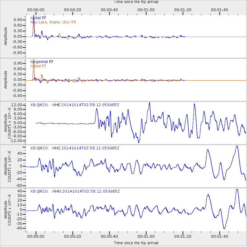
Signal To Noise
| Channel | StoN | STA | LTA |
| X8:QM20: :HHZ:20141014T03:58:12.059985Z | 32.574574 | 1.0960734E-5 | 3.3648126E-7 |
| X8:QM20: :HHN:20141014T03:58:12.059985Z | 23.636726 | 4.924935E-6 | 2.0835944E-7 |
| X8:QM20: :HHE:20141014T03:58:12.059985Z | 19.61494 | 4.148497E-6 | 2.114968E-7 |
| Arrivals |
| Ps | 4.5 SECOND |
| PpPs | 13 SECOND |
| PsPs/PpSs | 17 SECOND |


