You are here: Home > Network List > X812 - Deep Structure of Three Continental Sutures in Eastern North America Stations List
> Station QM00 Howards Cove, Maine, USA > Earthquake Result Viewer
QM00 Howards Cove, Maine, USA - Earthquake Result Viewer
| Earthquake location: |
Off Coast Of Central America |
| Earthquake latitude/longitude: |
12.6/-88.0 |
| Earthquake time(UTC): |
2014/10/14 (287) 03:51:35 GMT |
| Earthquake Depth: |
40 km |
| Earthquake Magnitude: |
7.3 MWW, 7.4 MI |
| Earthquake Catalog/Contributor: |
NEIC PDE/NEIC COMCAT |
|
| Network: |
X8 Deep Structure of Three Continental Sutures in Eastern North America |
| Station: |
QM00 Howards Cove, Maine, USA |
| Lat/Lon: |
44.62 N/67.39 W |
| Elevation: |
15 m |
|
| Distance: |
36.5 deg |
| Az: |
25.057 deg |
| Baz: |
215.381 deg |
| Ray Param: |
0.07656004 |
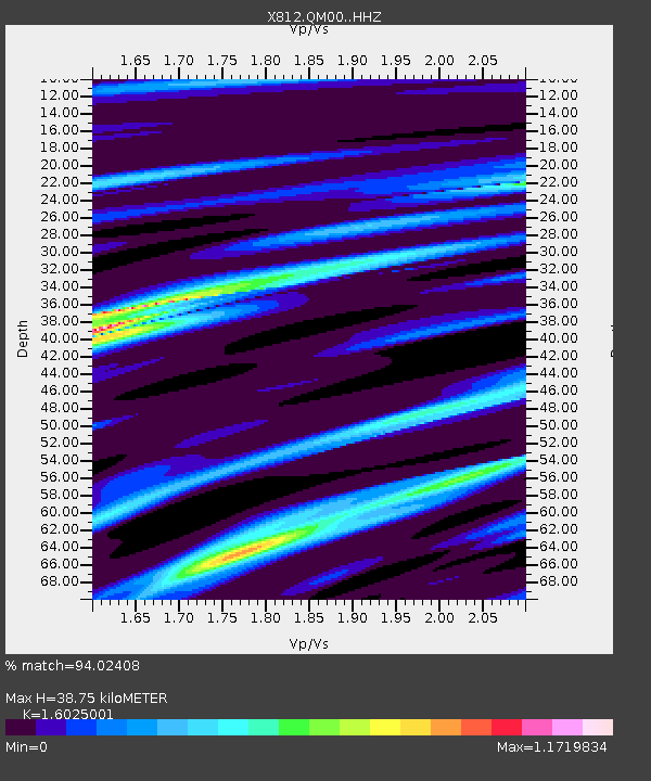
| Estimated Moho Depth: |
38.75 km |
| Estimated Crust Vp/Vs: |
1.60 |
| Assumed Crust Vp: |
6.419 km/s |
| Estimated Crust Vs: |
4.006 km/s |
| Estimated Crust Poisson's Ratio: |
0.18 |
|
| Radial Match: |
94.02408 % |
| Radial Bump: |
400 |
| Transverse Match: |
80.13737 % |
| Transverse Bump: |
400 |
| SOD ConfigId: |
3390531 |
| Insert Time: |
2019-04-14 13:20:30.714 +0000 |
| GWidth: |
2.5 |
| Max Bumps: |
400 |
| Tol: |
0.001 |
|

Signal To Noise
| Channel | StoN | STA | LTA |
| X8:QM00: :HHZ:20141014T03:58:05.870013Z | 27.521235 | 1.02513395E-5 | 3.7248836E-7 |
| X8:QM00: :HHN:20141014T03:58:05.870013Z | 17.641056 | 5.1063557E-6 | 2.8945863E-7 |
| X8:QM00: :HHE:20141014T03:58:05.870013Z | 10.51856 | 4.669477E-6 | 4.4392743E-7 |
| Arrivals |
| Ps | 4.0 SECOND |
| PpPs | 14 SECOND |
| PsPs/PpSs | 18 SECOND |


