You are here: Home > Network List > X812 - Deep Structure of Three Continental Sutures in Eastern North America Stations List
> Station QM31 Togue Pond, Maine, USA > Earthquake Result Viewer
QM31 Togue Pond, Maine, USA - Earthquake Result Viewer
| Earthquake location: |
Off Coast Of Central America |
| Earthquake latitude/longitude: |
12.6/-88.0 |
| Earthquake time(UTC): |
2014/10/14 (287) 03:51:35 GMT |
| Earthquake Depth: |
40 km |
| Earthquake Magnitude: |
7.3 MWW, 7.4 MI |
| Earthquake Catalog/Contributor: |
NEIC PDE/NEIC COMCAT |
|
| Network: |
X8 Deep Structure of Three Continental Sutures in Eastern North America |
| Station: |
QM31 Togue Pond, Maine, USA |
| Lat/Lon: |
46.93 N/68.89 W |
| Elevation: |
0.0 m |
|
| Distance: |
37.9 deg |
| Az: |
21.503 deg |
| Baz: |
211.48 deg |
| Ray Param: |
0.07580832 |
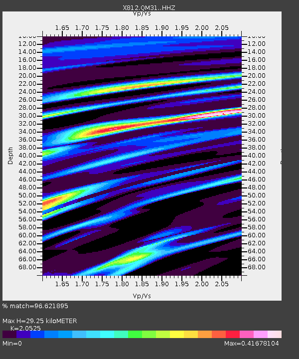
| Estimated Moho Depth: |
29.25 km |
| Estimated Crust Vp/Vs: |
2.05 |
| Assumed Crust Vp: |
6.419 km/s |
| Estimated Crust Vs: |
3.128 km/s |
| Estimated Crust Poisson's Ratio: |
0.34 |
|
| Radial Match: |
96.621895 % |
| Radial Bump: |
214 |
| Transverse Match: |
85.79664 % |
| Transverse Bump: |
400 |
| SOD ConfigId: |
3390531 |
| Insert Time: |
2019-04-14 13:20:31.408 +0000 |
| GWidth: |
2.5 |
| Max Bumps: |
400 |
| Tol: |
0.001 |
|

Signal To Noise
| Channel | StoN | STA | LTA |
| X8:QM31: :HHZ:20141014T03:58:17.309985Z | 23.978977 | 9.302265E-6 | 3.8793416E-7 |
| X8:QM31: :HHN:20141014T03:58:17.309985Z | 9.914311 | 4.435557E-6 | 4.4738934E-7 |
| X8:QM31: :HHE:20141014T03:58:17.309985Z | 10.767158 | 3.4552272E-6 | 3.2090432E-7 |
| Arrivals |
| Ps | 5.1 SECOND |
| PpPs | 13 SECOND |
| PsPs/PpSs | 18 SECOND |


