You are here: Home > Network List > X812 - Deep Structure of Three Continental Sutures in Eastern North America Stations List
> Station QMHP Harpswell, Maine > Earthquake Result Viewer
QMHP Harpswell, Maine - Earthquake Result Viewer
| Earthquake location: |
Off Coast Of Central America |
| Earthquake latitude/longitude: |
12.6/-88.0 |
| Earthquake time(UTC): |
2014/10/14 (287) 03:51:35 GMT |
| Earthquake Depth: |
40 km |
| Earthquake Magnitude: |
7.3 MWW, 7.4 MI |
| Earthquake Catalog/Contributor: |
NEIC PDE/NEIC COMCAT |
|
| Network: |
X8 Deep Structure of Three Continental Sutures in Eastern North America |
| Station: |
QMHP Harpswell, Maine |
| Lat/Lon: |
43.75 N/70.01 W |
| Elevation: |
22 m |
|
| Distance: |
34.7 deg |
| Az: |
23.196 deg |
| Baz: |
212.046 deg |
| Ray Param: |
0.07750867 |
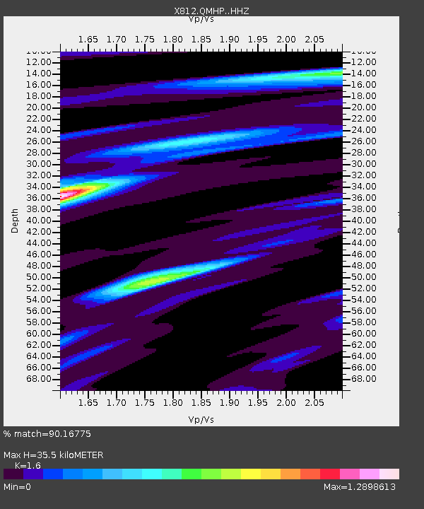
| Estimated Moho Depth: |
35.5 km |
| Estimated Crust Vp/Vs: |
1.60 |
| Assumed Crust Vp: |
6.419 km/s |
| Estimated Crust Vs: |
4.012 km/s |
| Estimated Crust Poisson's Ratio: |
0.18 |
|
| Radial Match: |
90.16775 % |
| Radial Bump: |
325 |
| Transverse Match: |
60.795715 % |
| Transverse Bump: |
400 |
| SOD ConfigId: |
3390531 |
| Insert Time: |
2019-04-14 13:20:40.061 +0000 |
| GWidth: |
2.5 |
| Max Bumps: |
400 |
| Tol: |
0.001 |
|

Signal To Noise
| Channel | StoN | STA | LTA |
| X8:QMHP: :HHZ:20141014T03:57:50.71001Z | 39.465954 | 1.0063056E-5 | 2.549807E-7 |
| X8:QMHP: :HHN:20141014T03:57:50.71001Z | 31.356709 | 5.73175E-6 | 1.8279184E-7 |
| X8:QMHP: :HHE:20141014T03:57:50.71001Z | 16.328276 | 4.065361E-6 | 2.4897673E-7 |
| Arrivals |
| Ps | 3.6 SECOND |
| PpPs | 13 SECOND |
| PsPs/PpSs | 17 SECOND |


