You are here: Home > Network List > XD14 - Illuminating the architecture of the greater Mount St. Helens magmatic systems f Stations List
> Station MD09 "Mount St Helens, WA" > Earthquake Result Viewer
MD09 "Mount St Helens, WA" - Earthquake Result Viewer
| Earthquake location: |
Off Coast Of Central America |
| Earthquake latitude/longitude: |
12.6/-88.0 |
| Earthquake time(UTC): |
2014/10/14 (287) 03:51:35 GMT |
| Earthquake Depth: |
40 km |
| Earthquake Magnitude: |
7.3 MWW, 7.4 MI |
| Earthquake Catalog/Contributor: |
NEIC PDE/NEIC COMCAT |
|
| Network: |
XD Illuminating the architecture of the greater Mount St. Helens magmatic systems f |
| Station: |
MD09 "Mount St Helens, WA" |
| Lat/Lon: |
46.50 N/121.71 W |
| Elevation: |
959 m |
|
| Distance: |
44.1 deg |
| Az: |
326.643 deg |
| Baz: |
128.997 deg |
| Ray Param: |
0.07201616 |
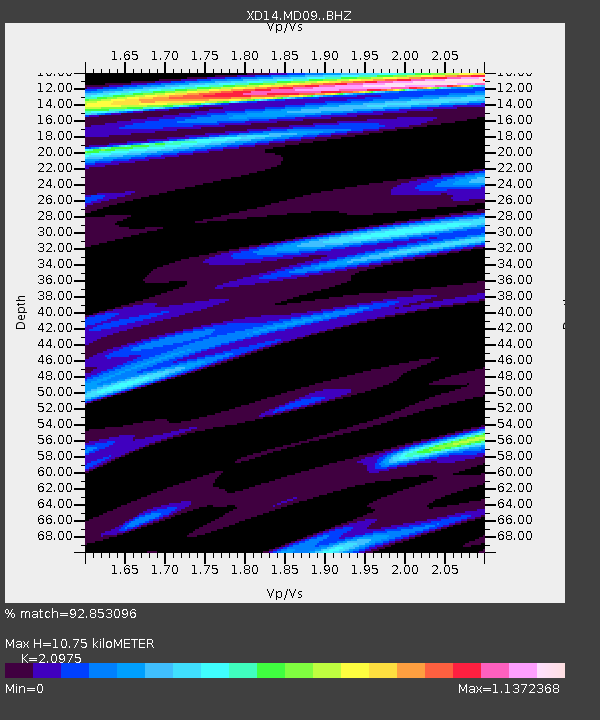
| Estimated Moho Depth: |
10.75 km |
| Estimated Crust Vp/Vs: |
2.10 |
| Assumed Crust Vp: |
6.597 km/s |
| Estimated Crust Vs: |
3.145 km/s |
| Estimated Crust Poisson's Ratio: |
0.35 |
|
| Radial Match: |
92.853096 % |
| Radial Bump: |
400 |
| Transverse Match: |
81.0792 % |
| Transverse Bump: |
400 |
| SOD ConfigId: |
3390531 |
| Insert Time: |
2019-04-14 13:20:48.315 +0000 |
| GWidth: |
2.5 |
| Max Bumps: |
400 |
| Tol: |
0.001 |
|

Signal To Noise
| Channel | StoN | STA | LTA |
| XD:MD09: :BHZ:20141014T03:59:08.604999Z | 8.81104 | 3.4384946E-6 | 3.9024843E-7 |
| XD:MD09: :BHN:20141014T03:59:08.604999Z | 2.6248245 | 1.0649422E-6 | 4.0571945E-7 |
| XD:MD09: :BHE:20141014T03:59:08.604999Z | 3.2205331 | 1.0652848E-6 | 3.3077902E-7 |
| Arrivals |
| Ps | 1.9 SECOND |
| PpPs | 4.8 SECOND |
| PsPs/PpSs | 6.7 SECOND |


