You are here: Home > Network List > XD14 - Illuminating the architecture of the greater Mount St. Helens magmatic systems f Stations List
> Station MH03 "Mount St Helens, WA" > Earthquake Result Viewer
MH03 "Mount St Helens, WA" - Earthquake Result Viewer
| Earthquake location: |
Off Coast Of Central America |
| Earthquake latitude/longitude: |
12.6/-88.0 |
| Earthquake time(UTC): |
2014/10/14 (287) 03:51:35 GMT |
| Earthquake Depth: |
40 km |
| Earthquake Magnitude: |
7.3 MWW, 7.4 MI |
| Earthquake Catalog/Contributor: |
NEIC PDE/NEIC COMCAT |
|
| Network: |
XD Illuminating the architecture of the greater Mount St. Helens magmatic systems f |
| Station: |
MH03 "Mount St Helens, WA" |
| Lat/Lon: |
46.27 N/122.59 W |
| Elevation: |
373 m |
|
| Distance: |
44.5 deg |
| Az: |
325.834 deg |
| Baz: |
127.778 deg |
| Ray Param: |
0.07180977 |
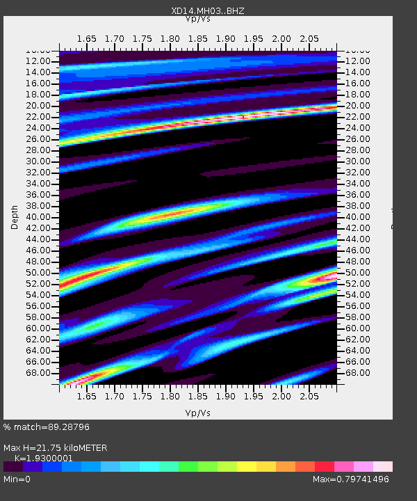
| Estimated Moho Depth: |
21.75 km |
| Estimated Crust Vp/Vs: |
1.93 |
| Assumed Crust Vp: |
6.566 km/s |
| Estimated Crust Vs: |
3.402 km/s |
| Estimated Crust Poisson's Ratio: |
0.32 |
|
| Radial Match: |
89.28796 % |
| Radial Bump: |
400 |
| Transverse Match: |
72.29176 % |
| Transverse Bump: |
400 |
| SOD ConfigId: |
3390531 |
| Insert Time: |
2019-04-14 13:21:01.798 +0000 |
| GWidth: |
2.5 |
| Max Bumps: |
400 |
| Tol: |
0.001 |
|

Signal To Noise
| Channel | StoN | STA | LTA |
| XD:MH03: :BHZ:20141014T03:59:11.284991Z | 4.724542 | 2.5064094E-6 | 5.3050843E-7 |
| XD:MH03: :BHN:20141014T03:59:11.284991Z | 2.2381523 | 1.2001108E-6 | 5.36206E-7 |
| XD:MH03: :BHE:20141014T03:59:11.284991Z | 1.9210898 | 1.0580815E-6 | 5.5077146E-7 |
| Arrivals |
| Ps | 3.3 SECOND |
| PpPs | 9.1 SECOND |
| PsPs/PpSs | 12 SECOND |


