You are here: Home > Network List > XD14 - Illuminating the architecture of the greater Mount St. Helens magmatic systems f Stations List
> Station MN09 "Mount St Helens, WA" > Earthquake Result Viewer
MN09 "Mount St Helens, WA" - Earthquake Result Viewer
| Earthquake location: |
Off Coast Of Central America |
| Earthquake latitude/longitude: |
12.6/-88.0 |
| Earthquake time(UTC): |
2014/10/14 (287) 03:51:35 GMT |
| Earthquake Depth: |
40 km |
| Earthquake Magnitude: |
7.3 MWW, 7.4 MI |
| Earthquake Catalog/Contributor: |
NEIC PDE/NEIC COMCAT |
|
| Network: |
XD Illuminating the architecture of the greater Mount St. Helens magmatic systems f |
| Station: |
MN09 "Mount St Helens, WA" |
| Lat/Lon: |
46.00 N/121.84 W |
| Elevation: |
1254 m |
|
| Distance: |
43.9 deg |
| Az: |
325.994 deg |
| Baz: |
128.433 deg |
| Ray Param: |
0.07216422 |
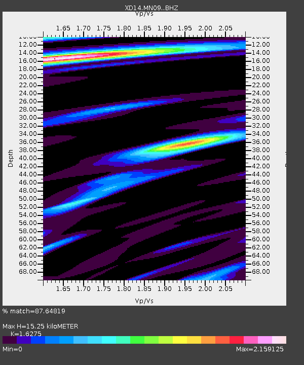
| Estimated Moho Depth: |
15.25 km |
| Estimated Crust Vp/Vs: |
1.63 |
| Assumed Crust Vp: |
6.597 km/s |
| Estimated Crust Vs: |
4.054 km/s |
| Estimated Crust Poisson's Ratio: |
0.20 |
|
| Radial Match: |
87.64819 % |
| Radial Bump: |
400 |
| Transverse Match: |
79.49238 % |
| Transverse Bump: |
400 |
| SOD ConfigId: |
3390531 |
| Insert Time: |
2019-04-14 13:21:27.247 +0000 |
| GWidth: |
2.5 |
| Max Bumps: |
400 |
| Tol: |
0.001 |
|

Signal To Noise
| Channel | StoN | STA | LTA |
| XD:MN09: :BHZ:20141014T03:59:06.670001Z | 14.657336 | 4.8538377E-6 | 3.3115415E-7 |
| XD:MN09: :BHN:20141014T03:59:06.670001Z | 1.7869003 | 1.430063E-6 | 8.003038E-7 |
| XD:MN09: :BHE:20141014T03:59:06.670001Z | 1.6225275 | 1.2505656E-6 | 7.7075157E-7 |
| Arrivals |
| Ps | 1.6 SECOND |
| PpPs | 5.6 SECOND |
| PsPs/PpSs | 7.2 SECOND |


