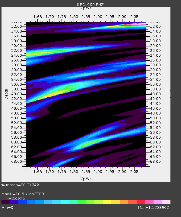
PALK Pallekele, Sri Lanka - Earthquake Result Viewer
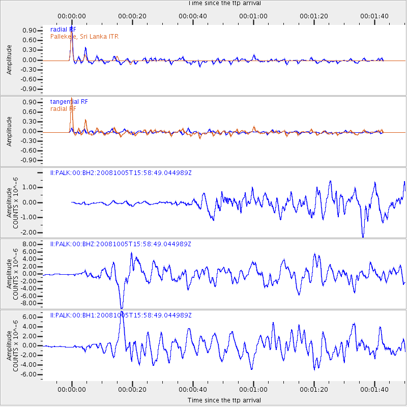
Earthquake location: Tajikistan-Xinjiang Border Reg.
Earthquake latitude/longitude: 39.5/73.8
Earthquake time(UTC): 2008/10/05 (279) 15:52:49 GMT
Earthquake Depth: 27 km
Earthquake Magnitude: 6.4 MB, 6.9 MS, 6.6 MW, 6.6 MW
Earthquake Catalog/Contributor: WHDF/NEIC
Network: II Global Seismograph Network (GSN - IRIS/IDA)
Station: PALK Pallekele, Sri Lanka
Lat/Lon: 7.27 N/80.70 E
Elevation: 460 m
Distance: 32.7 deg
Az: 167.299 deg
Baz: 350.131 deg
Ray Param: 0.07849957
Estimated Moho Depth: 10.5 km
Estimated Crust Vp/Vs: 2.10
Assumed Crust Vp: 6.545 km/s
Estimated Crust Vs: 3.121 km/s
Estimated Crust Poisson's Ratio: 0.35
Radial Match: 90.31742 %
Radial Bump: 323
Transverse Match: 81.82601 %
Transverse Bump: 400
SOD ConfigId: 590571
Insert Time: 2013-09-27 04:48:26.291 +0000
GWidth: 2.5
Max Bumps: 400
Tol: 0.001

Signal To Noise

ChannelStoNSTALTA
II:PALK:00:BHZ:20081005T15:58:49.044989Z3.63165554.1201307E-71.1345048E-7
II:PALK:00:BH1:20081005T15:58:49.044989Z4.56166743.53118E-77.740985E-8
II:PALK:00:BH2:20081005T15:58:49.044989Z0.84299466.352368E-87.5354784E-8
Arrivals
Ps1.9 SECOND
PpPs4.6 SECOND
PsPs/PpSs6.5 SECOND