You are here: Home > Network List > IU - Global Seismograph Network (GSN - IRIS/USGS) Stations List
> Station RSSD Black Hills, South Dakota, USA > Earthquake Result Viewer
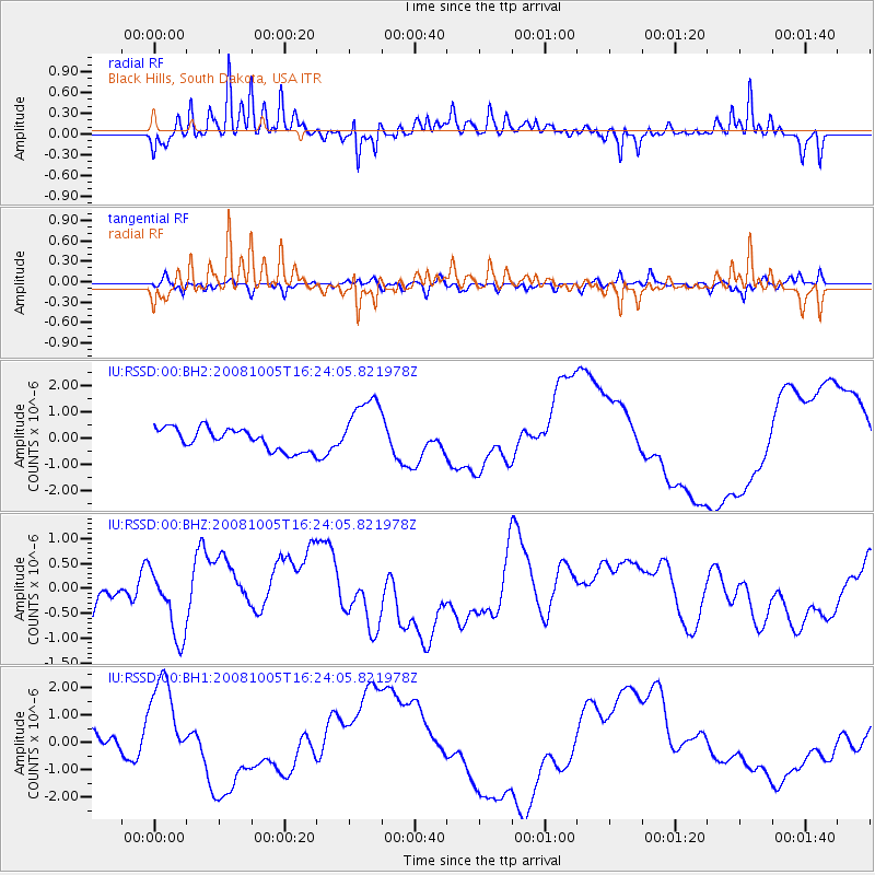
RSSD Black Hills, South Dakota, USA - Earthquake Result Viewer
*The percent match for this event was below the threshold and hence no stack was calculated.
| Earthquake location: |
Tajikistan-Xinjiang Border Reg. |
| Earthquake latitude/longitude: |
39.5/73.9 |
| Earthquake time(UTC): |
2008/10/05 (279) 16:11:10 GMT |
| Earthquake Depth: |
35 km |
| Earthquake Magnitude: |
5.6 MB |
| Earthquake Catalog/Contributor: |
WHDF/NEIC |
|
| Network: |
IU Global Seismograph Network (GSN - IRIS/USGS) |
| Station: |
RSSD Black Hills, South Dakota, USA |
| Lat/Lon: |
44.12 N/104.04 W |
| Elevation: |
2060 m |
|
| Distance: |
96.7 deg |
| Az: |
358.495 deg |
| Baz: |
1.617 deg |
| Ray Param: |
$rayparam |
*The percent match for this event was below the threshold and hence was not used in the summary stack. |
|
| Radial Match: |
52.42677 % |
| Radial Bump: |
400 |
| Transverse Match: |
50.824024 % |
| Transverse Bump: |
400 |
| SOD ConfigId: |
590571 |
| Insert Time: |
2013-09-27 04:50:48.147 +0000 |
| GWidth: |
2.5 |
| Max Bumps: |
400 |
| Tol: |
0.001 |
|
Signal To Noise
| Channel | StoN | STA | LTA |
| IU:RSSD:00:BHZ:20081005T16:24:05.821978Z | 2.0464826 | 6.453264E-7 | 3.1533443E-7 |
| IU:RSSD:00:BH1:20081005T16:24:05.821978Z | 3.4570398 | 1.6984582E-6 | 4.913042E-7 |
| IU:RSSD:00:BH2:20081005T16:24:05.821978Z | 2.9181943 | 1.2035429E-6 | 4.1242726E-7 |
| Arrivals |
| Ps | |
| PpPs | |
| PsPs/PpSs | |


