You are here: Home > Network List > US - United States National Seismic Network Stations List
> Station MSO Missoula, Montana, USA > Earthquake Result Viewer
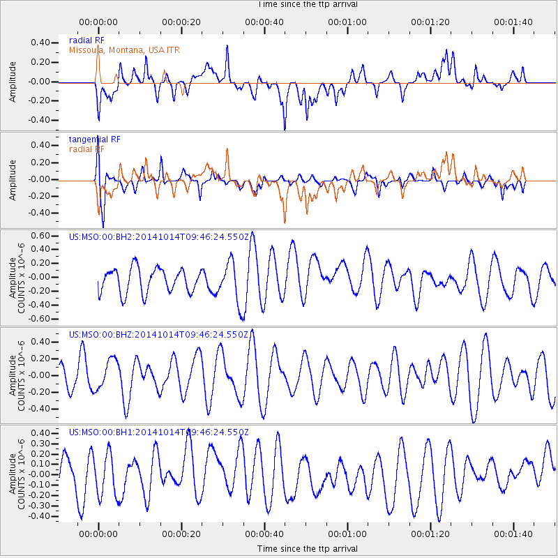
MSO Missoula, Montana, USA - Earthquake Result Viewer
*The percent match for this event was below the threshold and hence no stack was calculated.
| Earthquake location: |
South Of Fiji Islands |
| Earthquake latitude/longitude: |
-24.9/-177.2 |
| Earthquake time(UTC): |
2014/10/14 (287) 09:34:05 GMT |
| Earthquake Depth: |
134 km |
| Earthquake Magnitude: |
4.6 mb |
| Earthquake Catalog/Contributor: |
ISC/ISC |
|
| Network: |
US United States National Seismic Network |
| Station: |
MSO Missoula, Montana, USA |
| Lat/Lon: |
46.83 N/113.94 W |
| Elevation: |
1264 m |
|
| Distance: |
91.4 deg |
| Az: |
37.853 deg |
| Baz: |
234.266 deg |
| Ray Param: |
$rayparam |
*The percent match for this event was below the threshold and hence was not used in the summary stack. |
|
| Radial Match: |
48.82441 % |
| Radial Bump: |
400 |
| Transverse Match: |
53.495922 % |
| Transverse Bump: |
400 |
| SOD ConfigId: |
3390531 |
| Insert Time: |
2019-04-14 13:38:30.913 +0000 |
| GWidth: |
2.5 |
| Max Bumps: |
400 |
| Tol: |
0.001 |
|
Signal To Noise
| Channel | StoN | STA | LTA |
| US:MSO:00:BHZ:20141014T09:46:24.550Z | 1.2779496 | 1.8174245E-7 | 1.422141E-7 |
| US:MSO:00:BH1:20141014T09:46:24.550Z | 1.1566422 | 2.0092912E-7 | 1.7371761E-7 |
| US:MSO:00:BH2:20141014T09:46:24.550Z | 1.7721778 | 3.0900017E-7 | 1.7436184E-7 |
| Arrivals |
| Ps | |
| PpPs | |
| PsPs/PpSs | |


