You are here: Home > Network List > II - Global Seismograph Network (GSN - IRIS/IDA) Stations List
> Station EFI Mount Kent, East Falkland Island > Earthquake Result Viewer
EFI Mount Kent, East Falkland Island - Earthquake Result Viewer
| Earthquake location: |
Tonga Islands |
| Earthquake latitude/longitude: |
-21.9/-173.8 |
| Earthquake time(UTC): |
2008/10/19 (293) 05:10:33 GMT |
| Earthquake Depth: |
29 km |
| Earthquake Magnitude: |
6.8 MB, 7.0 MS, 6.9 MW, 6.9 MW |
| Earthquake Catalog/Contributor: |
WHDF/NEIC |
|
| Network: |
II Global Seismograph Network (GSN - IRIS/IDA) |
| Station: |
EFI Mount Kent, East Falkland Island |
| Lat/Lon: |
51.68 S/58.06 W |
| Elevation: |
110 m |
|
| Distance: |
87.8 deg |
| Az: |
145.859 deg |
| Baz: |
236.853 deg |
| Ray Param: |
0.043024648 |
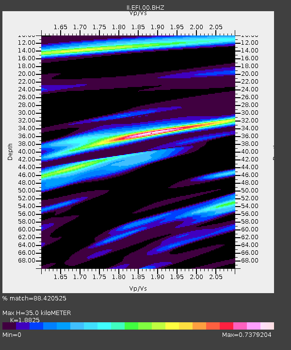
| Estimated Moho Depth: |
35.0 km |
| Estimated Crust Vp/Vs: |
1.88 |
| Assumed Crust Vp: |
6.472 km/s |
| Estimated Crust Vs: |
3.438 km/s |
| Estimated Crust Poisson's Ratio: |
0.30 |
|
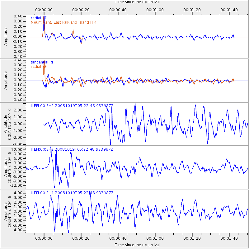
| Radial Match: |
88.420525 % |
| Radial Bump: |
400 |
| Transverse Match: |
63.664665 % |
| Transverse Bump: |
400 |
| SOD ConfigId: |
590571 |
| Insert Time: |
2013-09-27 05:12:22.662 +0000 |
| GWidth: |
2.5 |
| Max Bumps: |
400 |
| Tol: |
0.001 |
|
Signal To Noise
| Channel | StoN | STA | LTA |
| II:EFI:00:BHZ:20081019T05:22:48.933987Z | 6.6778164 | 5.3335775E-6 | 7.9870085E-7 |
| II:EFI:00:BH1:20081019T05:22:48.933987Z | 1.8202195 | 1.6779214E-6 | 9.218237E-7 |
| II:EFI:00:BH2:20081019T05:22:48.933987Z | 2.5621138 | 1.2885699E-6 | 5.029324E-7 |
| Arrivals |
| Ps | 4.9 SECOND |
| PpPs | 15 SECOND |
| PsPs/PpSs | 20 SECOND |


