You are here: Home > Network List > IU - Global Seismograph Network (GSN - IRIS/USGS) Stations List
> Station RSSD Black Hills, South Dakota, USA > Earthquake Result Viewer
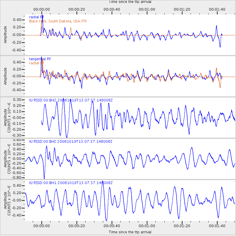
RSSD Black Hills, South Dakota, USA - Earthquake Result Viewer
*The percent match for this event was below the threshold and hence no stack was calculated.
| Earthquake location: |
Tonga Islands |
| Earthquake latitude/longitude: |
-22.0/-173.7 |
| Earthquake time(UTC): |
2008/10/19 (293) 12:55:05 GMT |
| Earthquake Depth: |
35 km |
| Earthquake Magnitude: |
5.7 MB, 5.3 MS, 5.6 MW, 5.5 MW |
| Earthquake Catalog/Contributor: |
WHDF/NEIC |
|
| Network: |
IU Global Seismograph Network (GSN - IRIS/USGS) |
| Station: |
RSSD Black Hills, South Dakota, USA |
| Lat/Lon: |
44.12 N/104.04 W |
| Elevation: |
2060 m |
|
| Distance: |
91.5 deg |
| Az: |
42.496 deg |
| Baz: |
240.536 deg |
| Ray Param: |
$rayparam |
*The percent match for this event was below the threshold and hence was not used in the summary stack. |
|
| Radial Match: |
65.142296 % |
| Radial Bump: |
400 |
| Transverse Match: |
61.032173 % |
| Transverse Bump: |
386 |
| SOD ConfigId: |
590571 |
| Insert Time: |
2013-09-27 05:14:42.510 +0000 |
| GWidth: |
2.5 |
| Max Bumps: |
400 |
| Tol: |
0.001 |
|
Signal To Noise
| Channel | StoN | STA | LTA |
| IU:RSSD:00:BHZ:20081019T13:07:37.148008Z | 2.7211237 | 3.489178E-7 | 1.2822564E-7 |
| IU:RSSD:00:BH1:20081019T13:07:37.148008Z | 0.8902328 | 1.3928103E-7 | 1.5645462E-7 |
| IU:RSSD:00:BH2:20081019T13:07:37.148008Z | 1.0958906 | 1.7400679E-7 | 1.5878116E-7 |
| Arrivals |
| Ps | |
| PpPs | |
| PsPs/PpSs | |


