You are here: Home > Network List > IU - Global Seismograph Network (GSN - IRIS/USGS) Stations List
> Station TATO Taipei, Taiwan > Earthquake Result Viewer
TATO Taipei, Taiwan - Earthquake Result Viewer

| Earthquake location: |
Tonga Islands |
| Earthquake latitude/longitude: |
-18.4/-175.4 |
| Earthquake time(UTC): |
2008/10/22 (296) 12:55:57 GMT |
| Earthquake Depth: |
233 km |
| Earthquake Magnitude: |
5.9 MB, 6.4 MW, 6.3 MW |
| Earthquake Catalog/Contributor: |
WHDF/NEIC |
|
| Network: |
IU Global Seismograph Network (GSN - IRIS/USGS) |
| Station: |
TATO Taipei, Taiwan |
| Lat/Lon: |
24.98 N/121.49 E |
| Elevation: |
53 m |
|
| Distance: |
75.1 deg |
| Az: |
303.071 deg |
| Baz: |
118.759 deg |
| Ray Param: |
0.051267616 |
| Estimated Moho Depth: |
16.5 km |
| Estimated Crust Vp/Vs: |
2.02 |
| Assumed Crust Vp: |
6.289 km/s |
| Estimated Crust Vs: |
3.121 km/s |
| Estimated Crust Poisson's Ratio: |
0.34 |
|
| Radial Match: |
90.58916 % |
| Radial Bump: |
372 |
| Transverse Match: |
83.98836 % |
| Transverse Bump: |
400 |
| SOD ConfigId: |
590571 |
| Insert Time: |
2013-09-27 05:18:51.726 +0000 |
| GWidth: |
2.5 |
| Max Bumps: |
400 |
| Tol: |
0.001 |
|
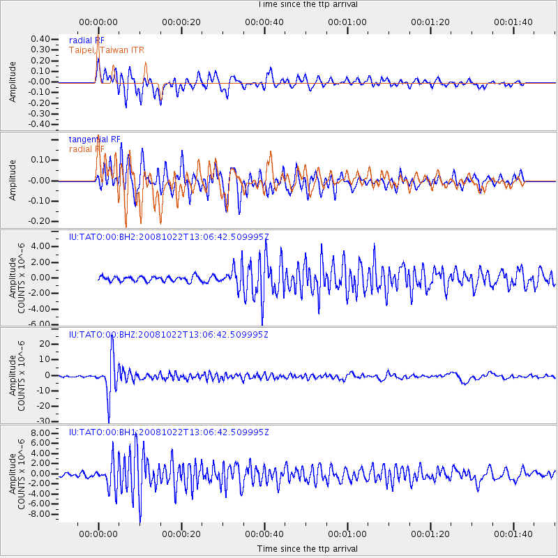
Signal To Noise
| Channel | StoN | STA | LTA |
| IU:TATO:00:BHZ:20081022T13:06:42.509995Z | 41.043022 | 1.2268418E-5 | 2.9891606E-7 |
| IU:TATO:00:BH1:20081022T13:06:42.509995Z | 6.916724 | 2.5395289E-6 | 3.6715772E-7 |
| IU:TATO:00:BH2:20081022T13:06:42.509995Z | 4.1677623 | 1.2636781E-6 | 3.0320302E-7 |
| Arrivals |
| Ps | 2.7 SECOND |
| PpPs | 7.7 SECOND |
| PsPs/PpSs | 10 SECOND |


