You are here: Home > Network List > II - Global Seismograph Network (GSN - IRIS/IDA) Stations List
> Station PALK Pallekele, Sri Lanka > Earthquake Result Viewer
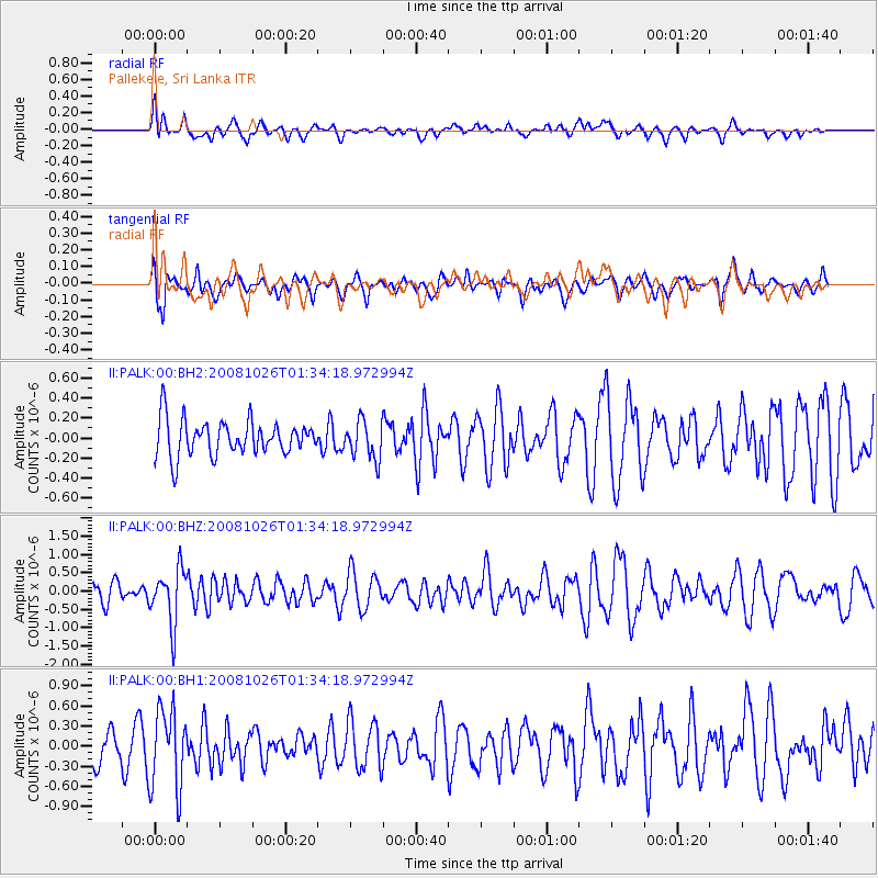
PALK Pallekele, Sri Lanka - Earthquake Result Viewer
*The percent match for this event was below the threshold and hence no stack was calculated.
| Earthquake location: |
Hindu Kush Region, Afghanistan |
| Earthquake latitude/longitude: |
36.5/70.7 |
| Earthquake time(UTC): |
2008/10/26 (300) 01:28:56 GMT |
| Earthquake Depth: |
210 km |
| Earthquake Magnitude: |
5.5 MB, 5.7 MW, 5.7 MW |
| Earthquake Catalog/Contributor: |
WHDF/NEIC |
|
| Network: |
II Global Seismograph Network (GSN - IRIS/IDA) |
| Station: |
PALK Pallekele, Sri Lanka |
| Lat/Lon: |
7.27 N/80.70 E |
| Elevation: |
460 m |
|
| Distance: |
30.5 deg |
| Az: |
160.112 deg |
| Baz: |
343.958 deg |
| Ray Param: |
$rayparam |
*The percent match for this event was below the threshold and hence was not used in the summary stack. |
|
| Radial Match: |
57.191437 % |
| Radial Bump: |
400 |
| Transverse Match: |
53.461113 % |
| Transverse Bump: |
400 |
| SOD ConfigId: |
590571 |
| Insert Time: |
2013-09-27 05:24:28.575 +0000 |
| GWidth: |
2.5 |
| Max Bumps: |
400 |
| Tol: |
0.001 |
|
Signal To Noise
| Channel | StoN | STA | LTA |
| II:PALK:00:BHZ:20081026T01:34:18.972994Z | 1.8841188 | 7.4700324E-7 | 3.9647352E-7 |
| II:PALK:00:BH1:20081026T01:34:18.972994Z | 1.6767622 | 5.9564593E-7 | 3.5523578E-7 |
| II:PALK:00:BH2:20081026T01:34:18.972994Z | 1.0820292 | 1.8971808E-7 | 1.7533544E-7 |
| Arrivals |
| Ps | |
| PpPs | |
| PsPs/PpSs | |


