You are here: Home > Network List > IU - Global Seismograph Network (GSN - IRIS/USGS) Stations List
> Station RSSD Black Hills, South Dakota, USA > Earthquake Result Viewer
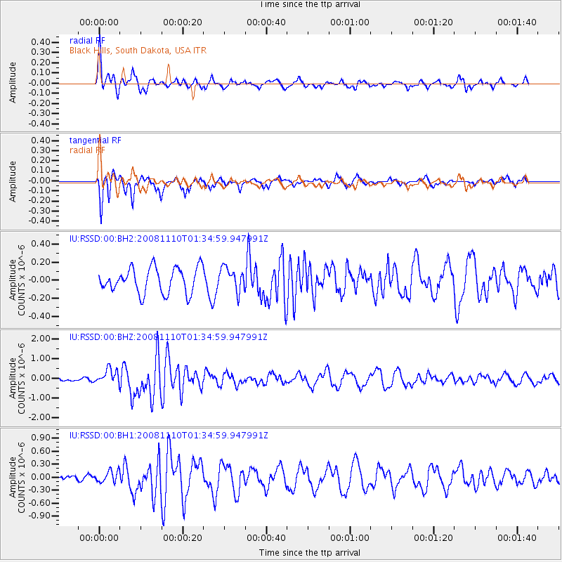
RSSD Black Hills, South Dakota, USA - Earthquake Result Viewer
*The percent match for this event was below the threshold and hence no stack was calculated.
| Earthquake location: |
Qinghai, China |
| Earthquake latitude/longitude: |
37.6/95.8 |
| Earthquake time(UTC): |
2008/11/10 (315) 01:22:02 GMT |
| Earthquake Depth: |
19 km |
| Earthquake Magnitude: |
6.4 MB, 6.4 MS, 6.3 MW, 6.3 MW |
| Earthquake Catalog/Contributor: |
WHDF/NEIC |
|
| Network: |
IU Global Seismograph Network (GSN - IRIS/USGS) |
| Station: |
RSSD Black Hills, South Dakota, USA |
| Lat/Lon: |
44.12 N/104.04 W |
| Elevation: |
2060 m |
|
| Distance: |
96.7 deg |
| Az: |
14.269 deg |
| Baz: |
344.22 deg |
| Ray Param: |
$rayparam |
*The percent match for this event was below the threshold and hence was not used in the summary stack. |
|
| Radial Match: |
62.15648 % |
| Radial Bump: |
299 |
| Transverse Match: |
69.79938 % |
| Transverse Bump: |
294 |
| SOD ConfigId: |
590571 |
| Insert Time: |
2013-09-27 05:59:36.608 +0000 |
| GWidth: |
2.5 |
| Max Bumps: |
400 |
| Tol: |
0.001 |
|
Signal To Noise
| Channel | StoN | STA | LTA |
| IU:RSSD:00:BHZ:20081110T01:34:59.947991Z | 1.9182501 | 3.838108E-7 | 2.0008382E-7 |
| IU:RSSD:00:BH1:20081110T01:34:59.947991Z | 1.2536012 | 1.3651007E-7 | 1.0889433E-7 |
| IU:RSSD:00:BH2:20081110T01:34:59.947991Z | 0.95222265 | 1.3217539E-7 | 1.3880722E-7 |
| Arrivals |
| Ps | |
| PpPs | |
| PsPs/PpSs | |


