You are here: Home > Network List > IU - Global Seismograph Network (GSN - IRIS/USGS) Stations List
> Station RSSD Black Hills, South Dakota, USA > Earthquake Result Viewer
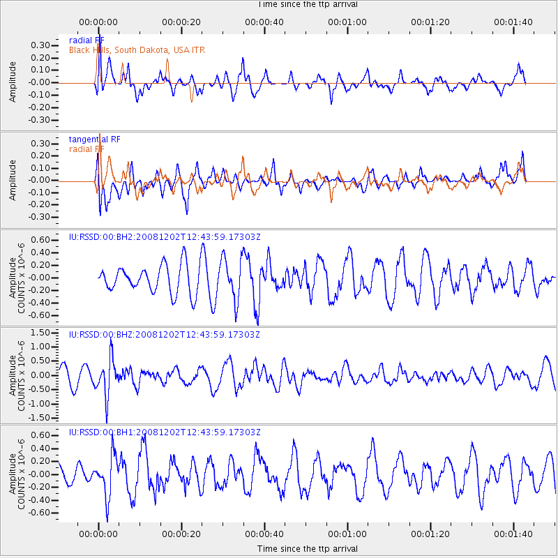
RSSD Black Hills, South Dakota, USA - Earthquake Result Viewer
*The percent match for this event was below the threshold and hence no stack was calculated.
| Earthquake location: |
Mariana Islands |
| Earthquake latitude/longitude: |
19.1/145.8 |
| Earthquake time(UTC): |
2008/12/02 (337) 12:31:43 GMT |
| Earthquake Depth: |
137 km |
| Earthquake Magnitude: |
5.9 MB, 5.9 MW, 5.9 MW |
| Earthquake Catalog/Contributor: |
WHDF/NEIC |
|
| Network: |
IU Global Seismograph Network (GSN - IRIS/USGS) |
| Station: |
RSSD Black Hills, South Dakota, USA |
| Lat/Lon: |
44.12 N/104.04 W |
| Elevation: |
2060 m |
|
| Distance: |
90.5 deg |
| Az: |
42.523 deg |
| Baz: |
297.454 deg |
| Ray Param: |
$rayparam |
*The percent match for this event was below the threshold and hence was not used in the summary stack. |
|
| Radial Match: |
55.660156 % |
| Radial Bump: |
400 |
| Transverse Match: |
51.077274 % |
| Transverse Bump: |
400 |
| SOD ConfigId: |
590571 |
| Insert Time: |
2013-09-27 07:03:18.610 +0000 |
| GWidth: |
2.5 |
| Max Bumps: |
400 |
| Tol: |
0.001 |
|
Signal To Noise
| Channel | StoN | STA | LTA |
| IU:RSSD:00:BHZ:20081202T12:43:59.17303Z | 1.9549359 | 6.447765E-7 | 3.2981976E-7 |
| IU:RSSD:00:BH1:20081202T12:43:59.17303Z | 1.5321406 | 3.2174128E-7 | 2.0999462E-7 |
| IU:RSSD:00:BH2:20081202T12:43:59.17303Z | 1.5079747 | 3.331478E-7 | 2.20924E-7 |
| Arrivals |
| Ps | |
| PpPs | |
| PsPs/PpSs | |


