You are here: Home > Network List > II - Global Seismograph Network (GSN - IRIS/IDA) Stations List
> Station MSEY Mahe, Seychelles > Earthquake Result Viewer
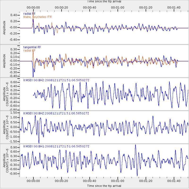
MSEY Mahe, Seychelles - Earthquake Result Viewer
*The percent match for this event was below the threshold and hence no stack was calculated.
| Earthquake location: |
Minahassa Peninsula, Sulawesi |
| Earthquake latitude/longitude: |
0.1/123.4 |
| Earthquake time(UTC): |
2008/12/11 (346) 21:40:52 GMT |
| Earthquake Depth: |
133 km |
| Earthquake Magnitude: |
6.1 MB, 5.9 MW, 5.9 MW |
| Earthquake Catalog/Contributor: |
WHDF/NEIC |
|
| Network: |
II Global Seismograph Network (GSN - IRIS/IDA) |
| Station: |
MSEY Mahe, Seychelles |
| Lat/Lon: |
4.67 S/55.48 E |
| Elevation: |
475 m |
|
| Distance: |
68.0 deg |
| Az: |
264.969 deg |
| Baz: |
88.058 deg |
| Ray Param: |
$rayparam |
*The percent match for this event was below the threshold and hence was not used in the summary stack. |
|
| Radial Match: |
48.90709 % |
| Radial Bump: |
400 |
| Transverse Match: |
55.687653 % |
| Transverse Bump: |
400 |
| SOD ConfigId: |
590571 |
| Insert Time: |
2013-09-27 07:35:46.057 +0000 |
| GWidth: |
2.5 |
| Max Bumps: |
400 |
| Tol: |
0.001 |
|
Signal To Noise
| Channel | StoN | STA | LTA |
| II:MSEY:00:BHZ:20081211T21:51:06.565027Z | 1.7530395 | 7.3134396E-7 | 4.1718627E-7 |
| II:MSEY:00:BH1:20081211T21:51:06.565027Z | 1.2141439 | 2.9333643E-7 | 2.415994E-7 |
| II:MSEY:00:BH2:20081211T21:51:06.565027Z | 0.90263456 | 2.5800227E-7 | 2.8583247E-7 |
| Arrivals |
| Ps | |
| PpPs | |
| PsPs/PpSs | |


