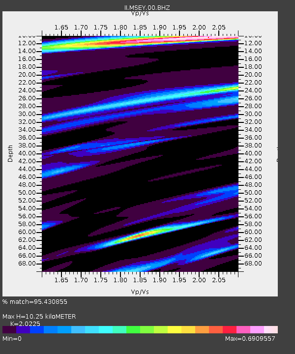
MSEY Mahe, Seychelles - Earthquake Result Viewer
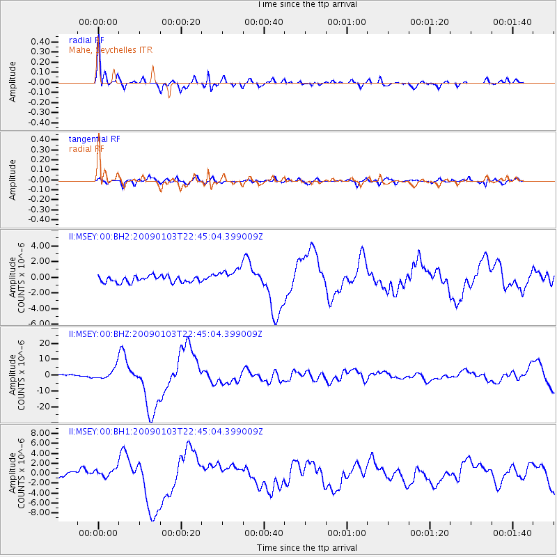
Earthquake location: Irian Jaya Region, Indonesia
Earthquake latitude/longitude: -0.7/133.3
Earthquake time(UTC): 2009/01/03 (003) 22:33:40 GMT
Earthquake Depth: 23 km
Earthquake Magnitude: 6.7 MB, 7.4 MS, 7.4 MW, 7.3 MW
Earthquake Catalog/Contributor: WHDF/NEIC
Network: II Global Seismograph Network (GSN - IRIS/IDA)
Station: MSEY Mahe, Seychelles
Lat/Lon: 4.67 S/55.48 E
Elevation: 475 m
Distance: 77.8 deg
Az: 265.399 deg
Baz: 89.699 deg
Ray Param: 0.050043967
Estimated Moho Depth: 10.25 km
Estimated Crust Vp/Vs: 2.02
Assumed Crust Vp: 6.303 km/s
Estimated Crust Vs: 3.116 km/s
Estimated Crust Poisson's Ratio: 0.34
Radial Match: 95.430855 %
Radial Bump: 395
Transverse Match: 82.99169 %
Transverse Bump: 400
SOD ConfigId: 590571
Insert Time: 2013-09-27 09:05:05.118 +0000
GWidth: 2.5
Max Bumps: 400
Tol: 0.001

Signal To Noise

ChannelStoNSTALTA
II:MSEY:00:BHZ:20090103T22:45:04.399009Z3.97511083.887627E-69.779922E-7
II:MSEY:00:BH1:20090103T22:45:04.399009Z1.04715498.8241256E-78.4267623E-7
II:MSEY:00:BH2:20090103T22:45:04.399009Z2.84075211.1181719E-63.9361822E-7
Arrivals
Ps1.7 SECOND
PpPs4.8 SECOND
PsPs/PpSs6.5 SECOND