You are here: Home > Network List > IU - Global Seismograph Network (GSN - IRIS/USGS) Stations List
> Station RSSD Black Hills, South Dakota, USA > Earthquake Result Viewer
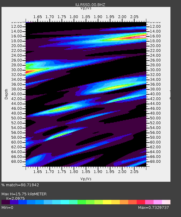
RSSD Black Hills, South Dakota, USA - Earthquake Result Viewer
| Earthquake location: |
East Of Kuril Islands |
| Earthquake latitude/longitude: |
46.9/155.2 |
| Earthquake time(UTC): |
2009/01/15 (015) 17:49:39 GMT |
| Earthquake Depth: |
36 km |
| Earthquake Magnitude: |
6.9 MB, 7.5 MS, 7.4 MW, 7.4 MW |
| Earthquake Catalog/Contributor: |
WHDF/NEIC |
|
| Network: |
IU Global Seismograph Network (GSN - IRIS/USGS) |
| Station: |
RSSD Black Hills, South Dakota, USA |
| Lat/Lon: |
44.12 N/104.04 W |
| Elevation: |
2060 m |
|
| Distance: |
65.7 deg |
| Az: |
50.928 deg |
| Baz: |
312.289 deg |
| Ray Param: |
0.05805522 |
| Estimated Moho Depth: |
15.75 km |
| Estimated Crust Vp/Vs: |
2.10 |
| Assumed Crust Vp: |
6.242 km/s |
| Estimated Crust Vs: |
2.976 km/s |
| Estimated Crust Poisson's Ratio: |
0.35 |
|
| Radial Match: |
98.71942 % |
| Radial Bump: |
262 |
| Transverse Match: |
92.60608 % |
| Transverse Bump: |
400 |
| SOD ConfigId: |
590571 |
| Insert Time: |
2013-09-27 09:24:25.460 +0000 |
| GWidth: |
2.5 |
| Max Bumps: |
400 |
| Tol: |
0.001 |
|

Signal To Noise
| Channel | StoN | STA | LTA |
| IU:RSSD:00:BHZ:20090115T17:59:49.010002Z | 21.81374 | 1.3137129E-5 | 6.02241E-7 |
| IU:RSSD:00:BH1:20090115T17:59:49.010002Z | 22.725523 | 6.5305053E-6 | 2.8736434E-7 |
| IU:RSSD:00:BH2:20090115T17:59:49.010002Z | 2.3329742 | 8.33314E-7 | 3.5718952E-7 |
| Arrivals |
| Ps | 2.9 SECOND |
| PpPs | 7.6 SECOND |
| PsPs/PpSs | 10 SECOND |


