You are here: Home > Network List > US - United States National Seismic Network Stations List
> Station KSU1 Kansas State University--Konza Prairie, Kansas, USA > Earthquake Result Viewer
KSU1 Kansas State University--Konza Prairie, Kansas, USA - Earthquake Result Viewer
| Earthquake location: |
East Of Kuril Islands |
| Earthquake latitude/longitude: |
46.9/155.2 |
| Earthquake time(UTC): |
2009/01/15 (015) 17:49:39 GMT |
| Earthquake Depth: |
36 km |
| Earthquake Magnitude: |
6.9 MB, 7.5 MS, 7.4 MW, 7.4 MW |
| Earthquake Catalog/Contributor: |
WHDF/NEIC |
|
| Network: |
US United States National Seismic Network |
| Station: |
KSU1 Kansas State University--Konza Prairie, Kansas, USA |
| Lat/Lon: |
39.10 N/96.61 W |
| Elevation: |
347 m |
|
| Distance: |
73.2 deg |
| Az: |
50.547 deg |
| Baz: |
317.077 deg |
| Ray Param: |
0.05313477 |
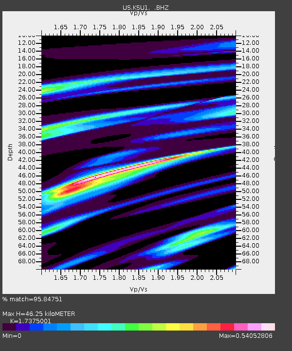
| Estimated Moho Depth: |
46.25 km |
| Estimated Crust Vp/Vs: |
1.74 |
| Assumed Crust Vp: |
6.483 km/s |
| Estimated Crust Vs: |
3.731 km/s |
| Estimated Crust Poisson's Ratio: |
0.25 |
|
| Radial Match: |
95.84751 % |
| Radial Bump: |
301 |
| Transverse Match: |
89.012535 % |
| Transverse Bump: |
400 |
| SOD ConfigId: |
590571 |
| Insert Time: |
2013-09-27 09:24:40.528 +0000 |
| GWidth: |
2.5 |
| Max Bumps: |
400 |
| Tol: |
0.001 |
|
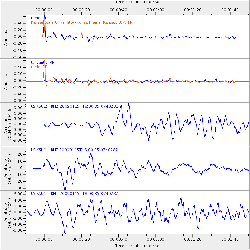
Signal To Noise
| Channel | StoN | STA | LTA |
| US:KSU1: :BHZ:20090115T18:00:35.074028Z | 17.629652 | 8.544364E-6 | 4.846587E-7 |
| US:KSU1: :BH1:20090115T18:00:35.074028Z | 4.1891546 | 2.100003E-6 | 5.012952E-7 |
| US:KSU1: :BH2:20090115T18:00:35.074028Z | 4.7178593 | 3.4892792E-6 | 7.3958944E-7 |
| Arrivals |
| Ps | 5.5 SECOND |
| PpPs | 19 SECOND |
| PsPs/PpSs | 24 SECOND |


