You are here: Home > Network List > IU - Global Seismograph Network (GSN - IRIS/USGS) Stations List
> Station TATO Taipei, Taiwan > Earthquake Result Viewer
TATO Taipei, Taiwan - Earthquake Result Viewer
| Earthquake location: |
Kermadec Islands Region |
| Earthquake latitude/longitude: |
-27.4/-176.3 |
| Earthquake time(UTC): |
2009/02/18 (049) 21:53:45 GMT |
| Earthquake Depth: |
25 km |
| Earthquake Magnitude: |
6.8 MB, 7.2 MS, 6.9 MW, 6.9 MW |
| Earthquake Catalog/Contributor: |
WHDF/NEIC |
|
| Network: |
IU Global Seismograph Network (GSN - IRIS/USGS) |
| Station: |
TATO Taipei, Taiwan |
| Lat/Lon: |
24.98 N/121.49 E |
| Elevation: |
53 m |
|
| Distance: |
79.4 deg |
| Az: |
305.25 deg |
| Baz: |
126.886 deg |
| Ray Param: |
0.048963904 |
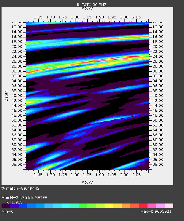
| Estimated Moho Depth: |
24.75 km |
| Estimated Crust Vp/Vs: |
1.96 |
| Assumed Crust Vp: |
6.289 km/s |
| Estimated Crust Vs: |
3.217 km/s |
| Estimated Crust Poisson's Ratio: |
0.32 |
|
| Radial Match: |
89.49442 % |
| Radial Bump: |
400 |
| Transverse Match: |
88.02303 % |
| Transverse Bump: |
400 |
| SOD ConfigId: |
590571 |
| Insert Time: |
2013-09-27 10:49:58.429 +0000 |
| GWidth: |
2.5 |
| Max Bumps: |
400 |
| Tol: |
0.001 |
|

Signal To Noise
| Channel | StoN | STA | LTA |
| IU:TATO:00:BHZ:20090218T22:05:17.660Z | 11.019753 | 2.3097511E-5 | 2.09601E-6 |
| IU:TATO:00:BH1:20090218T22:05:17.660Z | 2.740266 | 3.9214515E-6 | 1.4310477E-6 |
| IU:TATO:00:BH2:20090218T22:05:17.660Z | 1.8496062 | 2.679453E-6 | 1.4486614E-6 |
| Arrivals |
| Ps | 3.9 SECOND |
| PpPs | 11 SECOND |
| PsPs/PpSs | 15 SECOND |


