You are here: Home > Network List > XL12 - Hangay Dome, Mongolia Stations List
> Station HV26 HV26 > Earthquake Result Viewer
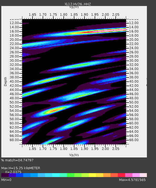
HV26 HV26 - Earthquake Result Viewer
| Earthquake location: |
Southeast Of Honshu, Japan |
| Earthquake latitude/longitude: |
31.7/140.5 |
| Earthquake time(UTC): |
2014/10/15 (288) 23:53:01 GMT |
| Earthquake Depth: |
58 km |
| Earthquake Magnitude: |
5.5 MWW, 5.5 MWC, 5.6 MWB |
| Earthquake Catalog/Contributor: |
NEIC PDE/NEIC COMCAT |
|
| Network: |
XL Hangay Dome, Mongolia |
| Station: |
HV26 HV26 |
| Lat/Lon: |
50.62 N/101.86 E |
| Elevation: |
1158 m |
|
| Distance: |
34.2 deg |
| Az: |
314.887 deg |
| Baz: |
108.624 deg |
| Ray Param: |
0.077732116 |
| Estimated Moho Depth: |
15.25 km |
| Estimated Crust Vp/Vs: |
2.04 |
| Assumed Crust Vp: |
6.419 km/s |
| Estimated Crust Vs: |
3.151 km/s |
| Estimated Crust Poisson's Ratio: |
0.34 |
|
| Radial Match: |
84.74797 % |
| Radial Bump: |
400 |
| Transverse Match: |
72.76622 % |
| Transverse Bump: |
400 |
| SOD ConfigId: |
3390531 |
| Insert Time: |
2019-04-14 14:16:22.702 +0000 |
| GWidth: |
2.5 |
| Max Bumps: |
400 |
| Tol: |
0.001 |
|

Signal To Noise
| Channel | StoN | STA | LTA |
| XL:HV26: :HHZ:20141015T23:59:10.858988Z | 11.398328 | 5.3185175E-7 | 4.6660507E-8 |
| XL:HV26: :HHN:20141015T23:59:10.858988Z | 3.4906087 | 3.079068E-7 | 8.821005E-8 |
| XL:HV26: :HHE:20141015T23:59:10.858988Z | 4.1251626 | 3.1382973E-7 | 7.607694E-8 |
| Arrivals |
| Ps | 2.6 SECOND |
| PpPs | 6.8 SECOND |
| PsPs/PpSs | 9.4 SECOND |


