You are here: Home > Network List > IU - Global Seismograph Network (GSN - IRIS/USGS) Stations List
> Station RSSD Black Hills, South Dakota, USA > Earthquake Result Viewer
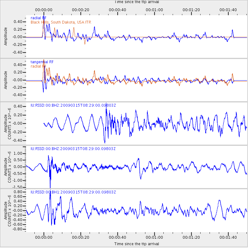
RSSD Black Hills, South Dakota, USA - Earthquake Result Viewer
*The percent match for this event was below the threshold and hence no stack was calculated.
| Earthquake location: |
Central Peru |
| Earthquake latitude/longitude: |
-14.5/-70.4 |
| Earthquake time(UTC): |
2009/03/15 (074) 08:19:05 GMT |
| Earthquake Depth: |
190 km |
| Earthquake Magnitude: |
5.7 MW, 5.1 MB, 5.6 MW |
| Earthquake Catalog/Contributor: |
WHDF/NEIC |
|
| Network: |
IU Global Seismograph Network (GSN - IRIS/USGS) |
| Station: |
RSSD Black Hills, South Dakota, USA |
| Lat/Lon: |
44.12 N/104.04 W |
| Elevation: |
2060 m |
|
| Distance: |
65.9 deg |
| Az: |
334.056 deg |
| Baz: |
143.951 deg |
| Ray Param: |
$rayparam |
*The percent match for this event was below the threshold and hence was not used in the summary stack. |
|
| Radial Match: |
64.48384 % |
| Radial Bump: |
400 |
| Transverse Match: |
63.29446 % |
| Transverse Bump: |
400 |
| SOD ConfigId: |
590571 |
| Insert Time: |
2013-09-27 11:46:12.478 +0000 |
| GWidth: |
2.5 |
| Max Bumps: |
400 |
| Tol: |
0.001 |
|
Signal To Noise
| Channel | StoN | STA | LTA |
| IU:RSSD:00:BHZ:20090315T08:29:00.09803Z | 2.0719943 | 4.5570374E-7 | 2.1993483E-7 |
| IU:RSSD:00:BH1:20090315T08:29:00.09803Z | 1.9637477 | 3.5226014E-7 | 1.7938156E-7 |
| IU:RSSD:00:BH2:20090315T08:29:00.09803Z | 1.9010061 | 1.9943379E-7 | 1.04909596E-7 |
| Arrivals |
| Ps | |
| PpPs | |
| PsPs/PpSs | |


