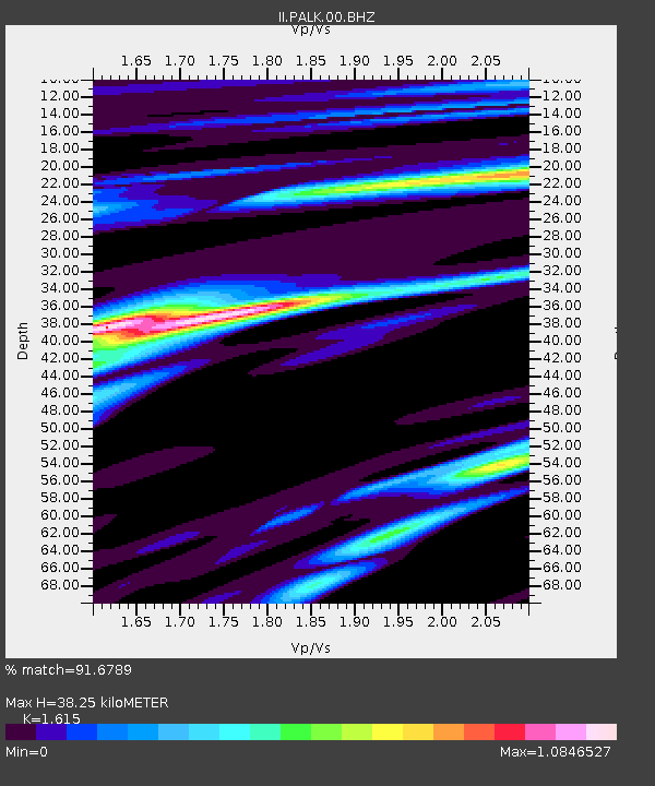
PALK Pallekele, Sri Lanka - Earthquake Result Viewer
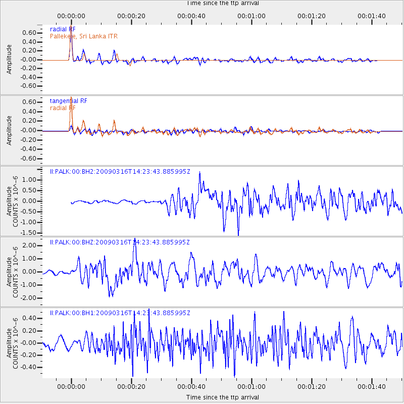
Earthquake location: Talaud Islands, Indonesia
Earthquake latitude/longitude: 3.8/126.6
Earthquake time(UTC): 2009/03/16 (075) 14:15:56 GMT
Earthquake Depth: 35 km
Earthquake Magnitude: 6.2 MB, 6.0 MS, 6.3 MW, 6.3 MW
Earthquake Catalog/Contributor: WHDF/NEIC
Network: II Global Seismograph Network (GSN - IRIS/IDA)
Station: PALK Pallekele, Sri Lanka
Lat/Lon: 7.27 N/80.70 E
Elevation: 460 m
Distance: 45.7 deg
Az: 276.405 deg
Baz: 91.758 deg
Ray Param: 0.071001895
Estimated Moho Depth: 38.25 km
Estimated Crust Vp/Vs: 1.62
Assumed Crust Vp: 6.545 km/s
Estimated Crust Vs: 4.053 km/s
Estimated Crust Poisson's Ratio: 0.19
Radial Match: 91.6789 %
Radial Bump: 400
Transverse Match: 75.8033 %
Transverse Bump: 400
SOD ConfigId: 590571
Insert Time: 2013-09-27 11:51:04.349 +0000
GWidth: 2.5
Max Bumps: 400
Tol: 0.001

Signal To Noise

ChannelStoNSTALTA
II:PALK:00:BHZ:20090316T14:23:43.885995Z5.34912445.264972E-79.8426796E-8
II:PALK:00:BH1:20090316T14:23:43.885995Z1.2846327.29809E-85.681075E-8
II:PALK:00:BH2:20090316T14:23:43.885995Z5.1433822.7054227E-75.2600072E-8
Arrivals
Ps3.9 SECOND
PpPs14 SECOND
PsPs/PpSs18 SECOND