You are here: Home > Network List > IU - Global Seismograph Network (GSN - IRIS/USGS) Stations List
> Station TATO Taipei, Taiwan > Earthquake Result Viewer
TATO Taipei, Taiwan - Earthquake Result Viewer
| Earthquake location: |
Tonga Islands Region |
| Earthquake latitude/longitude: |
-23.0/-174.7 |
| Earthquake time(UTC): |
2009/03/19 (078) 18:17:40 GMT |
| Earthquake Depth: |
34 km |
| Earthquake Magnitude: |
7.0 MB, 7.6 MS, 7.6 MW, 7.6 MW |
| Earthquake Catalog/Contributor: |
WHDF/NEIC |
|
| Network: |
IU Global Seismograph Network (GSN - IRIS/USGS) |
| Station: |
TATO Taipei, Taiwan |
| Lat/Lon: |
24.98 N/121.49 E |
| Elevation: |
53 m |
|
| Distance: |
78.2 deg |
| Az: |
303.658 deg |
| Baz: |
122.349 deg |
| Ray Param: |
0.049773846 |
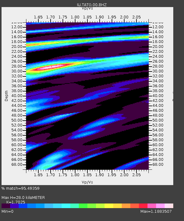
| Estimated Moho Depth: |
28.0 km |
| Estimated Crust Vp/Vs: |
1.70 |
| Assumed Crust Vp: |
6.289 km/s |
| Estimated Crust Vs: |
3.694 km/s |
| Estimated Crust Poisson's Ratio: |
0.24 |
|
| Radial Match: |
95.49359 % |
| Radial Bump: |
400 |
| Transverse Match: |
94.85869 % |
| Transverse Bump: |
400 |
| SOD ConfigId: |
590571 |
| Insert Time: |
2013-09-27 11:57:53.000 +0000 |
| GWidth: |
2.5 |
| Max Bumps: |
400 |
| Tol: |
0.001 |
|
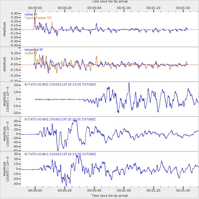
Signal To Noise
| Channel | StoN | STA | LTA |
| IU:TATO:00:BHZ:20090319T18:29:05.597988Z | 12.763807 | 6.8144254E-6 | 5.338866E-7 |
| IU:TATO:00:BH1:20090319T18:29:05.597988Z | 3.5815706 | 1.4226129E-6 | 3.9720365E-7 |
| IU:TATO:00:BH2:20090319T18:29:05.597988Z | 2.643362 | 9.509933E-7 | 3.597666E-7 |
| Arrivals |
| Ps | 3.2 SECOND |
| PpPs | 12 SECOND |
| PsPs/PpSs | 15 SECOND |


