You are here: Home > Network List > IU - Global Seismograph Network (GSN - IRIS/USGS) Stations List
> Station RSSD Black Hills, South Dakota, USA > Earthquake Result Viewer
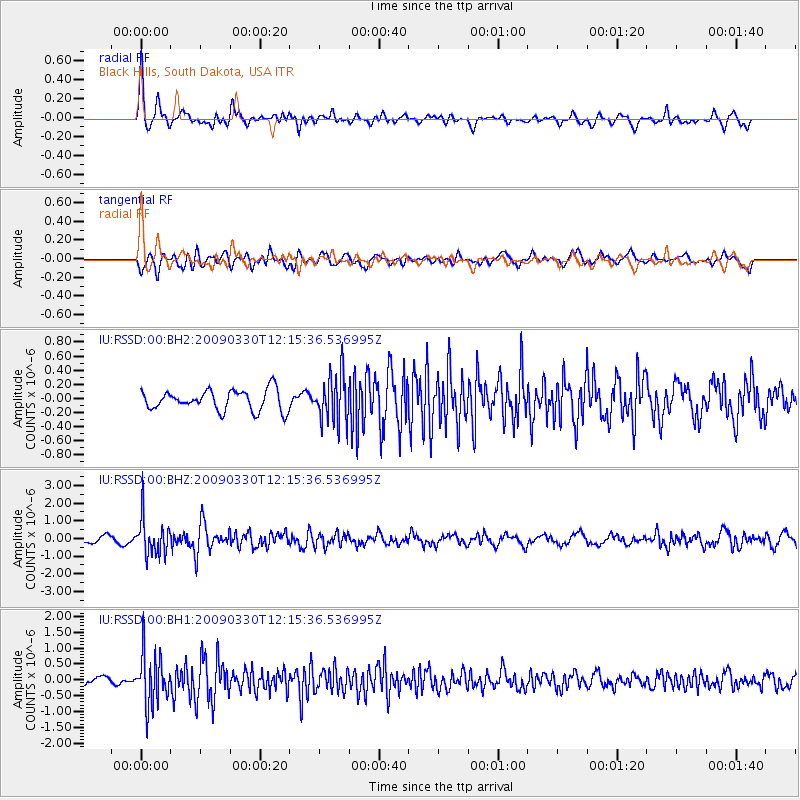
RSSD Black Hills, South Dakota, USA - Earthquake Result Viewer
*The percent match for this event was below the threshold and hence no stack was calculated.
| Earthquake location: |
Andreanof Islands, Aleutian Is. |
| Earthquake latitude/longitude: |
51.5/-178.3 |
| Earthquake time(UTC): |
2009/03/30 (089) 12:07:28 GMT |
| Earthquake Depth: |
31 km |
| Earthquake Magnitude: |
6.0 MB, 5.5 MS, 5.7 MW, 5.7 MW |
| Earthquake Catalog/Contributor: |
WHDF/NEIC |
|
| Network: |
IU Global Seismograph Network (GSN - IRIS/USGS) |
| Station: |
RSSD Black Hills, South Dakota, USA |
| Lat/Lon: |
44.12 N/104.04 W |
| Elevation: |
2060 m |
|
| Distance: |
48.4 deg |
| Az: |
67.974 deg |
| Baz: |
306.491 deg |
| Ray Param: |
$rayparam |
*The percent match for this event was below the threshold and hence was not used in the summary stack. |
|
| Radial Match: |
75.4445 % |
| Radial Bump: |
400 |
| Transverse Match: |
65.12407 % |
| Transverse Bump: |
400 |
| SOD ConfigId: |
590571 |
| Insert Time: |
2013-09-27 12:14:52.650 +0000 |
| GWidth: |
2.5 |
| Max Bumps: |
400 |
| Tol: |
0.001 |
|
Signal To Noise
| Channel | StoN | STA | LTA |
| IU:RSSD:00:BHZ:20090330T12:15:36.536995Z | 5.710627 | 1.0418366E-6 | 1.8243821E-7 |
| IU:RSSD:00:BH1:20090330T12:15:36.536995Z | 6.906039 | 8.108234E-7 | 1.1740788E-7 |
| IU:RSSD:00:BH2:20090330T12:15:36.536995Z | 2.3910553 | 3.456023E-7 | 1.4453965E-7 |
| Arrivals |
| Ps | |
| PpPs | |
| PsPs/PpSs | |


