You are here: Home > Network List > II - Global Seismograph Network (GSN - IRIS/IDA) Stations List
> Station AAK Ala Archa, Kyrgyzstan > Earthquake Result Viewer
AAK Ala Archa, Kyrgyzstan - Earthquake Result Viewer

| Earthquake location: |
Mindanao, Philippines |
| Earthquake latitude/longitude: |
6.9/126.6 |
| Earthquake time(UTC): |
2001/01/01 (001) 06:57:04 GMT |
| Earthquake Depth: |
33 km |
| Earthquake Magnitude: |
6.4 MB, 7.2 MS, 7.5 MW, 7.3 ME |
| Earthquake Catalog/Contributor: |
WHDF/NEIC |
|
| Network: |
II Global Seismograph Network (GSN - IRIS/IDA) |
| Station: |
AAK Ala Archa, Kyrgyzstan |
| Lat/Lon: |
42.64 N/74.49 E |
| Elevation: |
1645 m |
|
| Distance: |
57.9 deg |
| Az: |
316.618 deg |
| Baz: |
112.455 deg |
| Ray Param: |
0.063107364 |
| Estimated Moho Depth: |
19.75 km |
| Estimated Crust Vp/Vs: |
1.62 |
| Assumed Crust Vp: |
6.306 km/s |
| Estimated Crust Vs: |
3.887 km/s |
| Estimated Crust Poisson's Ratio: |
0.19 |
|
| Radial Match: |
97.24955 % |
| Radial Bump: |
400 |
| Transverse Match: |
89.0274 % |
| Transverse Bump: |
400 |
| SOD ConfigId: |
3744 |
| Insert Time: |
2010-03-01 15:23:30.015 +0000 |
| GWidth: |
2.5 |
| Max Bumps: |
400 |
| Tol: |
0.001 |
|
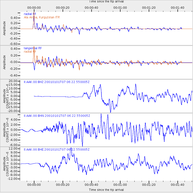
Signal To Noise
| Channel | StoN | STA | LTA |
| II:AAK:00:BHN:20010101T07:06:22.550005Z | 1.5139972 | 2.6550887E-7 | 1.7536945E-7 |
| II:AAK:00:BHE:20010101T07:06:22.550005Z | 3.3947701 | 7.2550404E-7 | 2.1371227E-7 |
| II:AAK:00:BHZ:20010101T07:06:22.550005Z | 4.562028 | 1.2665125E-6 | 2.776205E-7 |
| Arrivals |
| Ps | 2.1 SECOND |
| PpPs | 7.8 SECOND |
| PsPs/PpSs | 9.9 SECOND |


