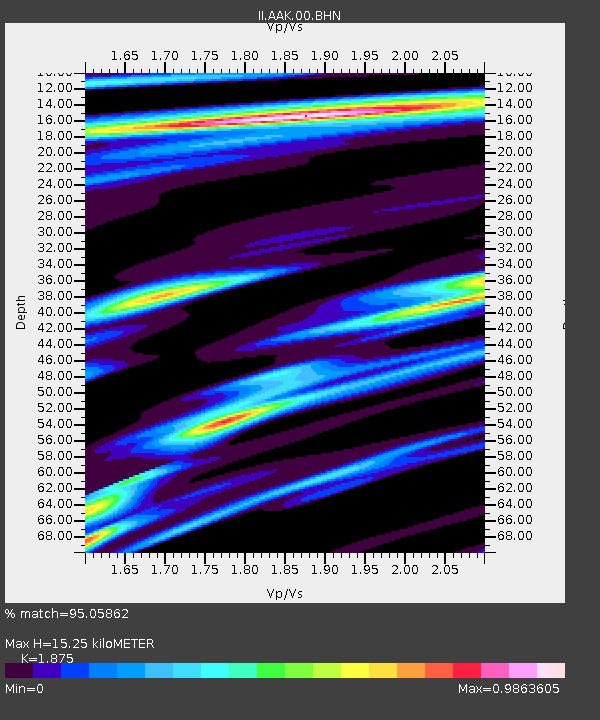
AAK Ala Archa, Kyrgyzstan - Earthquake Result Viewer

Earthquake location: Southern Sumatra, Indonesia
Earthquake latitude/longitude: -4.7/102.6
Earthquake time(UTC): 2001/02/13 (044) 19:28:30 GMT
Earthquake Depth: 36 km
Earthquake Magnitude: 6.2 MB, 7.2 MS, 7.4 MW, 7.0 ME
Earthquake Catalog/Contributor: WHDF/NEIC
Network: II Global Seismograph Network (GSN - IRIS/IDA)
Station: AAK Ala Archa, Kyrgyzstan
Lat/Lon: 42.64 N/74.49 E
Elevation: 1645 m
Distance: 53.5 deg
Az: 334.425 deg
Baz: 144.331 deg
Ray Param: 0.065959856
Estimated Moho Depth: 15.25 km
Estimated Crust Vp/Vs: 1.88
Assumed Crust Vp: 6.306 km/s
Estimated Crust Vs: 3.363 km/s
Estimated Crust Poisson's Ratio: 0.30
Radial Match: 95.05862 %
Radial Bump: 400
Transverse Match: 90.241905 %
Transverse Bump: 400
SOD ConfigId: 3744
Insert Time: 2010-03-01 15:23:32.282 +0000
GWidth: 2.5
Max Bumps: 400
Tol: 0.001

Signal To Noise

ChannelStoNSTALTA
II:AAK:00:BHN:20010213T19:37:16.793997Z1.76374941.4821501E-78.403405E-8
II:AAK:00:BHE:20010213T19:37:16.793997Z2.24483511.6503276E-77.3516645E-8
II:AAK:00:BHZ:20010213T19:37:16.793997Z2.2730293.2184295E-71.4159208E-7
Arrivals
Ps2.2 SECOND
PpPs6.6 SECOND
PsPs/PpSs8.8 SECOND